Region Overview
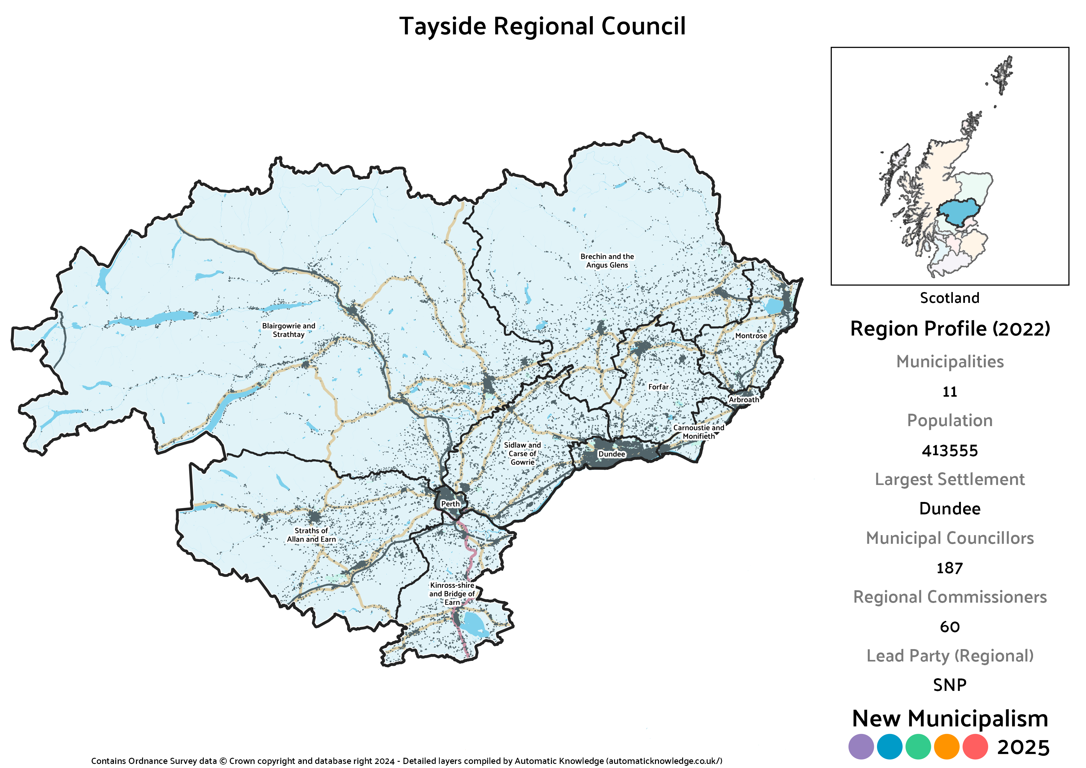
Key Statistics
Municipalities: 11
Population: 413,555
Largest Settlement: Dundee
Municipal Councillors: 187
Regional Commissioners: 60
Description
In principle, the 1973 Act’s Tayside Region was perfectly sound, so the basic outline was transposed intact both here and in the previous version of this project. As you’d expect though, where it differs is in having a wider range of underlying municipalities. This Region includes the current Angus, Dundee and Perth & Kinross Councils, which were the Districts in the previous setup. That means in historic terms it takes in Angus, Kinross-shire and most of Perthshire, sans a large chunk that was given over to Stirling and a much smaller one to Clackmannanshire under that Act. This would be the only region in the country to contain two cities, pairing Dundee (one of our big four) with Perth (one of our little four).
Unlike Scotland’s two largest cities I haven’t given Dundee, the fourth largest, a unitary authority. The fear with the big two was that they’d overpower the surrounding areas or go too far in terms of dismantling historic neighbouring counties. Neither of those issues apply to Dundee. In population terms it’s about 37% of Tayside, and as Regional Councils weight against larger municipalities, only 28% of the seats.
In political terms, all of these areas are historic SNP heartlands and so they end up with a comfortable lead at both levels. However, the Conservatives remain a solid force in the region outside of Dundee, so easily place second. Labour are weak outside of Dundee, with this region containing some rare fifth places for the party, and the Lib Dems have some strange local support across parts of the region that doesn’t exist at parliamentary level, meaning both parties are nearly tied. All of the non-city councils have at least some Independents, and the Greens also have a fair degree of representation albeit mostly on the Perthshire end and Dundee. Despite Dundee being the only place they ran a full slate of candidates in 2022, Alba fail to cross the 3% threshold in any municipality.
Projected Overall Municipal Election Results (2022)
Votes
Seats
Projected Overall Regional Election Results (2022)
Votes
Seats
Note: Bear in mind that for the regional results on an individual municipality basis below, the final seat is allocated from a region-wide levelling process. This means that whilst the distribution of seats is correctly proportional across the whole region, that is not necessarily the case in an individual municipality. The party that won each municipality’s levelling seat is marked by an asterisk * next to their name on the Votes chart.
Arbroath Burgh
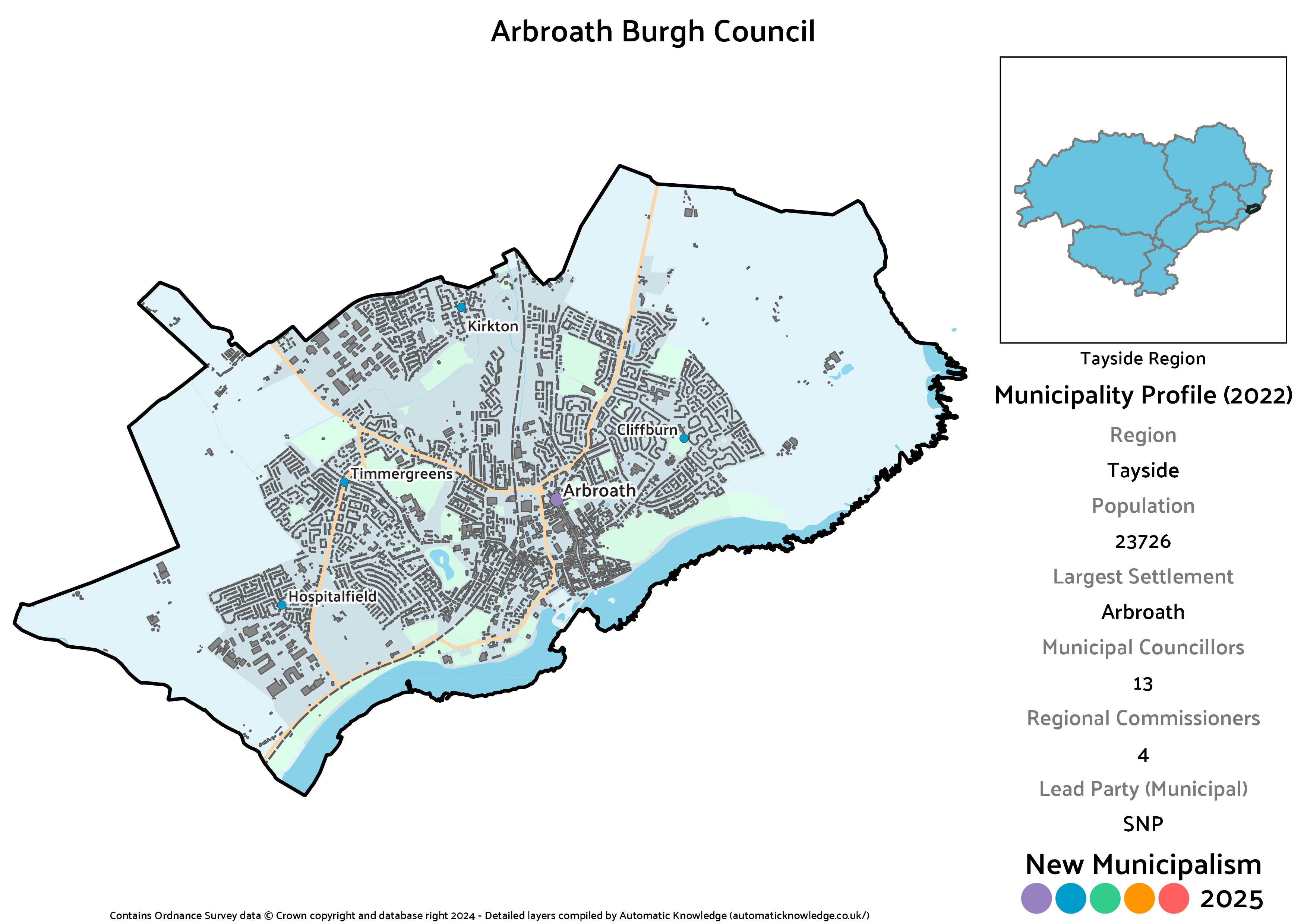
Key Statistics
Population: 23,726
Largest Settlement: Arbroath
Municipal Councillors: 13
Regional Commissioners: 4
Description
With Dundee having been on its own for over a century now, Arbroath has served as the largest town in the county of Angus. It’s a place weel kent at least by name to many Scots thanks to the 14th Century “Declaration of Arbroath”, which perhaps holds a place in Scottish constitutional history equivalent in mythic importance (if not in effect) to England’s Magna Carta. It remains an important town to this day, and formerly had its own Burgh Council. Restoring that historic status is an easy target for this project, given the size of the town, with only cosmetic changes since the 2020 version.
No surprises it’s the SNP that are easily the largest party here, coming up one seat short of a majority. The second largest bloc would be a cluster of Independents, most popular being Lois Speed (elected in Arbroath East and Lunan in reality), joined by Ian Wren and David Fairweather (unsuccessful and successful, in reverse of their first preference order, in Arbroath West, Letham and Friockheim). That’d be equal to the trio of Conservatives, leaving the last seat for Labour, though they also pick up a regional commissioner thanks to levelling seats. Though both narrowly cross the threshold, it’s not enough in a bare-minimum 13-seater for either the Lib Dems or Greens to get a seat, though their regional tally (which follows reallocation of Independent votes) shows they might otherwise have managed it.
Projected Municipal Election Results (2022)
Votes
Seats
Projected Regional Election Results (2022)
Votes
Seats
Blairgowrie and Strathtay
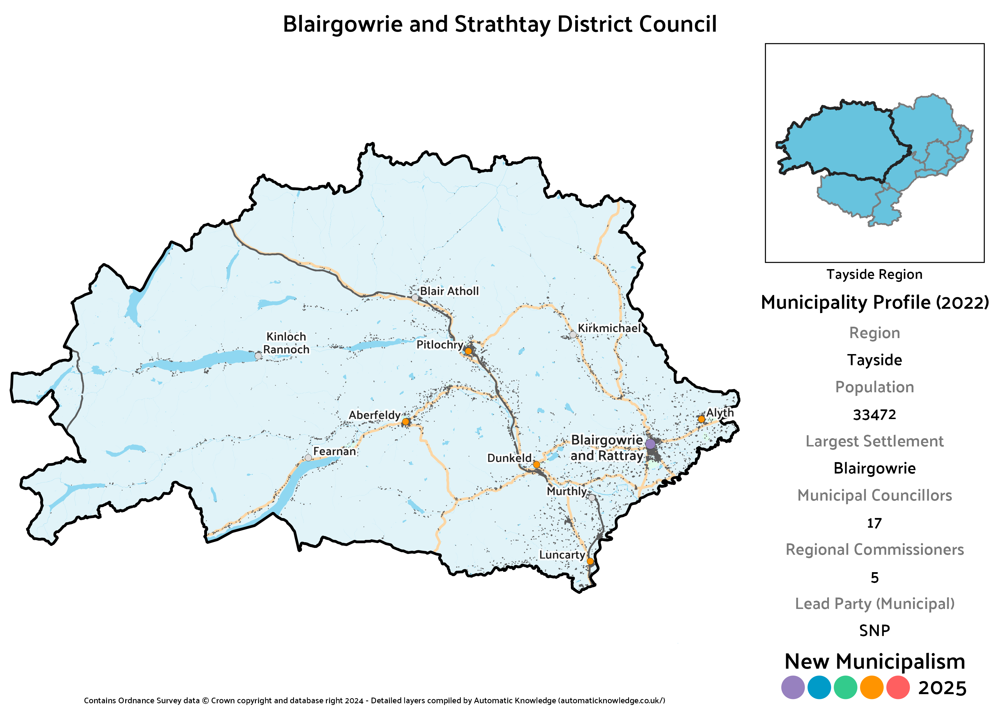
Key Statistics
Population: 33,472
Largest Settlement: Blairgowrie
Municipal Councillors: 17
Regional Commissioners: 5
Description
This massive District covers most of Perthshire, with a large chunk of the population concentrated in the southeast around the old twin Burghs of Blairgowrie and Rattray. The rest of the population can be seen in those trailing fingers of roads and buildings that follow the course of a number of rivers, most prominently the Tay itself which passes by Aberfeldy and the Tummel which passes Pitlochry. There are also less populous tracts along the Ardle and Garry.
The political makeup of this one involves both dominance and diversity. In the dominance stakes, only the SNP and Conservatives would have multiple councillors, taking over three quarters of the votes and seats between them, with the SNP a seat ahead. On the diversity side of things, the other three major parties all have a seat, as does one Independent in Xander McDade (elected in Highland). The Greens carry that over into the regional level to be awarded a seat via the levelling mechanism, whereas this is the lowest share for Labour of any municipality contested in the region.
Projected Municipal Election Results (2022)
Votes
Seats
Projected Regional Election Results (2022)
Votes
Seats
Brechin and the Angus Glens District
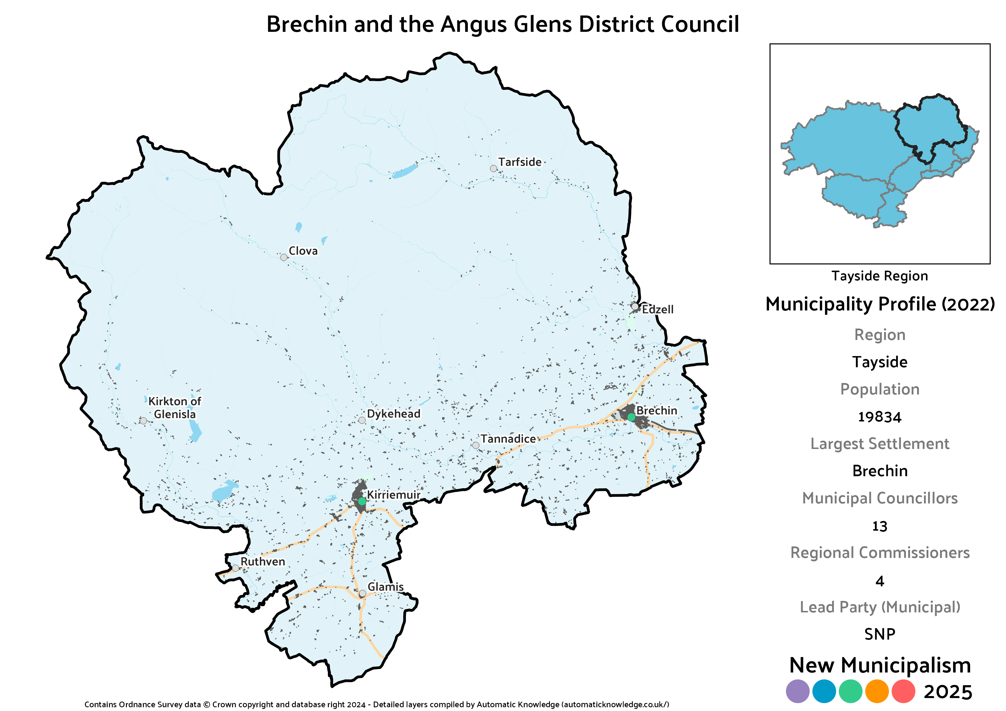
Key Statistics
Population: 19,834
Largest Settlement: Brechin
Municipal Councillors: 13
Regional Commissioners: 4
Description
This is an only slightly changed version of the Angus Glens district from the 2020 version of this project, with a little expansion in the southwest to take in the area around Glamis. This otherwise remains focused on the primary towns at Brechin and Kirriemuir, as the vast majority of the area of the district is taken up with the very sparsely populated Angus Glens themselves. This comes in a smidge below the 20,000 threshold but that’s fine for a predominantly rural district.
Per the Angus norm, this would primarily be a contest between the SNP and Conservatives, with the former edging very slightly ahead. Everyone else does have a seat, including Independent Jill Brown Scott (elected in Brechin and Edzell). Her transfers plus accounting for Alba make for an interesting difference between levels, with the Greens the strongest of the three smaller parties at municipal level, this being their best result in the region, but narrowly the weakest at regional level.
Projected Municipal Election Results (2022)
Votes
Seats
Projected Regional Election Results (2022)
Votes
Seats
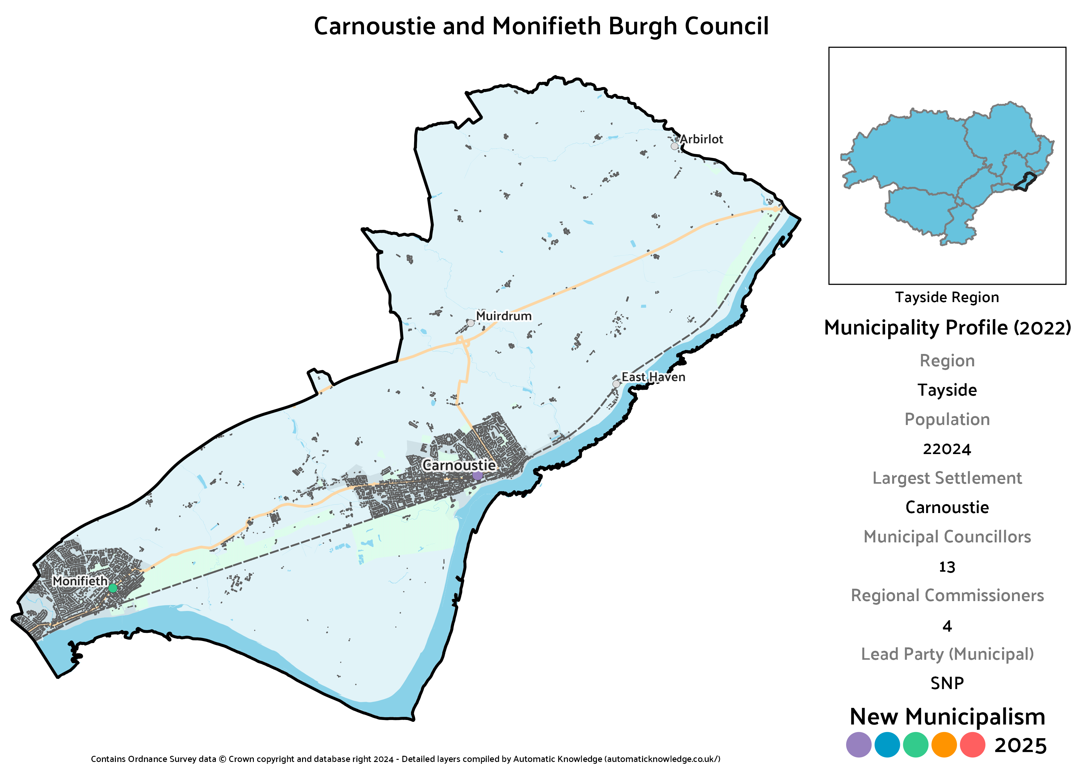
Carnoustie and Monifieth Burgh
Key Statistics
Population: 22,024
Largest Settlement: Carnoustie
Municipal Councillors: 13
Regional Commissioners: 5
Description
This Burgh does what it says on the tin, combining Carnoustie and Monifieth on the coast, plus a limited inland stretch around Muirdrum and Arbirlot. This represents a bit of a change since the 2020 iteration, losing some of the Sidlaw villages north of Dundee. Now, I don’t want to be negative, but I hate this one. It really bothers me. I am afraid to say that Monifieth is problematic. Although I did consider, in direct contravention to my approach with the other big cities, re-attaching it to Dundee as it had been under the old 1973 Districts model, doing so leaves Carnoustie an unfortunately awkward dangler on the coast with no sensible alternative arrangement.
So, I keep it out, but look at that western boundary – notice it doesn’t follow the Dighty Water? Perhaps a little tidying would be in order, trading the portion west of the water to Dundee for Panmurefield and Balmossie, which lie east of it? Ah, no, because Monifieth High School is in that western portion. So, we have an awkward boundary with Dundee as a result. It just bothers me! Monifieth, sort yourself out.
Naturally it’s the SNP out in front here, with the Conservatives a good bit behind. Angus loves an Independent councillor, but that’s especially true of Carnoustie, with votes there contributing the two Independents (David Cheape and Brian Boyd) notionally elected in this district. Reflecting the fact it was their only Angus councillor in reality, it’s the only non-city municipality on the Angus side to elect more than one Labour councillor, whilst reflecting the fact it’s the ward they used to have a councillor in, the Lib Dems pick up the levelling seat at regional level. The Greens fall short of the threshold, but this is one where Independent transfers suggest they’d have gotten in on a purely partisan election.
Projected Municipal Election Results (2022)
Votes
Seats
Projected Regional Election Results (2022)
Votes
Seats
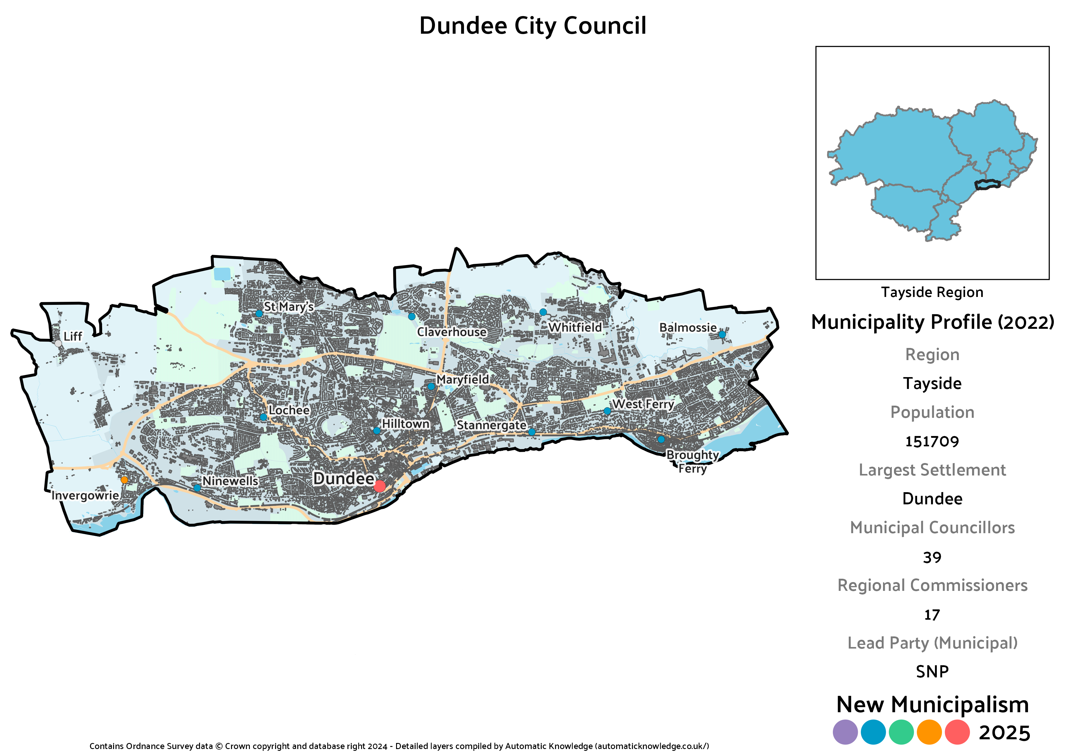
Dundee City
Key Statistics
Population: 151,709
Largest Settlement: Dundee
Municipal Councillors: 39
Regional Commissioners: 17
Description
Scotland’s fourth largest city, Dundee would be the natural anchor point for the whole Tayside region. Compared to the other four big cities, I’ve taken a very slightly different approach with Dundee, which is that it actually picks up a little bit of extra surrounding territory compared to the existing area, and the 2020 version, by incorporating Invergowrie plus the entirety of Liff. As noted in the above entry, it almost had Monifieth re-attached as well, but for some irritating geography.
Politically, Dundee was one of only two councils with a majority elected in 2022. A more proportional voting system doesn’t allow for that to occur on such a low vote share, so whilst the SNP remain clearly dominant in this scenario and with their best share in the region, they come up significantly short of a majority. Even a pair of Green councillors are not sufficient to create a majority bloc. Labour meanwhile are a quite distant second, albeit with their best result in the region, and the Lib Dems were strong here too, pushing the Conservatives into fourth place. Given the number of regional seats up for grabs, this is the one municipality in the region where every party wins at least one regional seat without needing the levelling mechanism.
Projected Municipal Election Results (2022)
Votes
Seats
Projected Regional Election Results (2022)
Votes
Seats
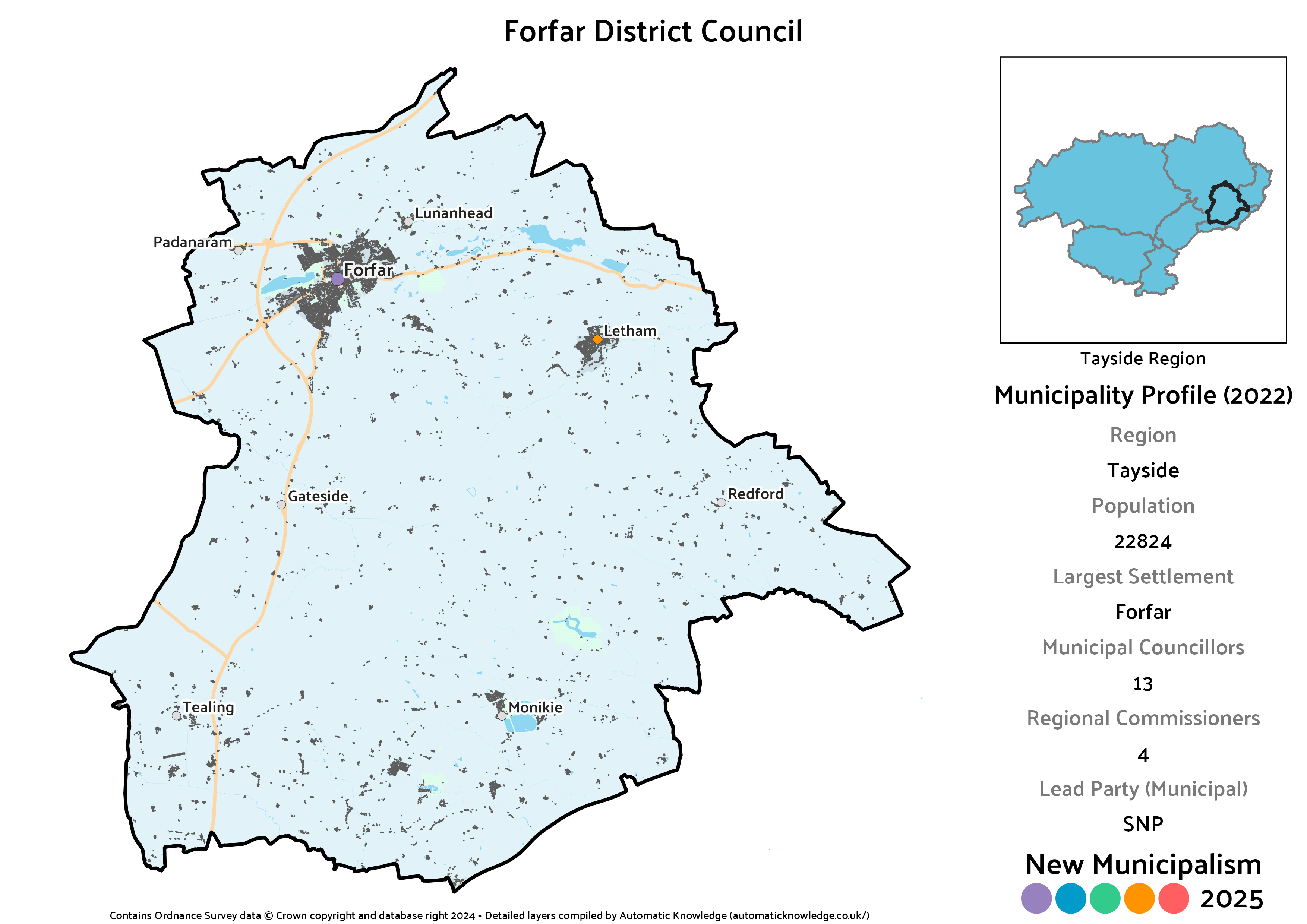
Forfar District
Key Statistics
Population: 22,824
Largest Settlement: Forfar
Municipal Councillors: 13
Regional Commissioners: 4
Description
Historically Angus’ county town, Forfar is one of many such towns to be eclipsed by a larger neighbour, in this case Arbroath. That means that for this project it acts as the centre of a wider district rather than being a burgh in its own right. It’s nonetheless the clear majority of the population here, with the only other sizeable settlement being at Letham. Compared to the 2020 version, this loses an area in the southwest including Glamis plus the villages northeast of Dundee such as Newtyle and Muirhead. It swaps in a stretch to the southeast, which covers Monikie, Wellbank and Newbigging.
If you’re reading these sequentially, absolutely no surprises that it’s the SNP taking a lead here with the Conservatives in second, plus a strong showing for Independents with two elected. Both stood in the Forfar and District ward in 2022, but only Ian McLaren was successful, as Colin Brown lost his seat. Labour and the Greens get a seat each, whilst the Lib Dems cross the threshold but not by enough to actually win a seat on the district council.
Projected Municipal Election Results (2022)
Votes
Seats
Projected Regional Election Results (2022)
Votes
Seats
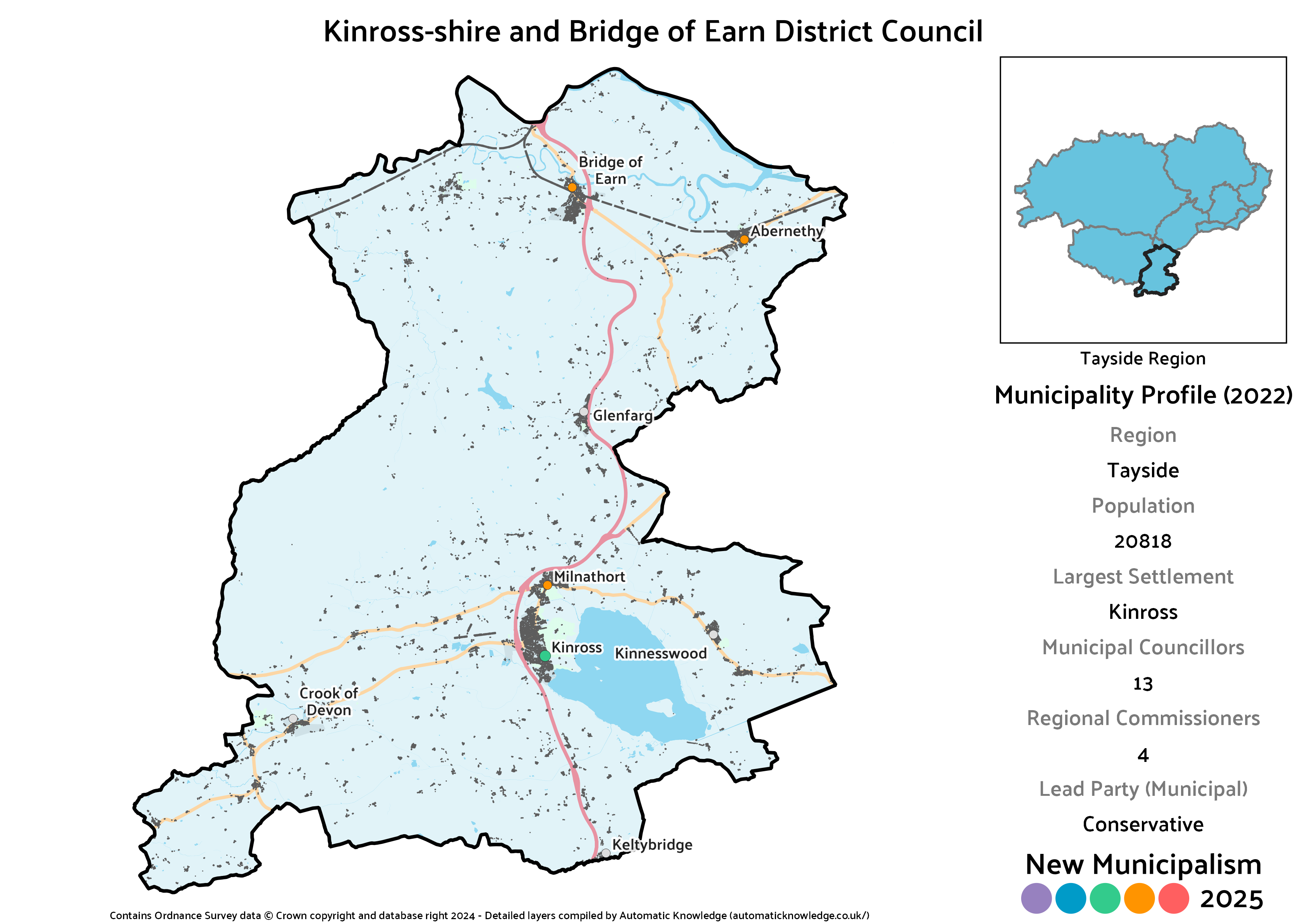
Kinross-shire and Bridge of Earn District
Key Statistics
Population: 20,818
Largest Settlement: Kinross
Municipal Councillors: 13
Regional Commissioners: 4
Description
Whilst a number of Scotland’s historic counties have been wiped from the map of local government through successive reforms, Kinross-shire has managed to half-survive. It’s long since ceased to have its own county governance, but a long-established link with Perthshire has seen it included within the name of the modern Perth and Kinross Council. Although I’ve restored, in part or in full, other historic counties elsewhere in this project, Kinross-shire is simply too small to be resurrected. Combining it instead with Bridge of Earn, as well as Abernethy and Glenfarg, from southern Perthshire actually makes for quite a neat district, as those areas wouldn’t really fit well with anywhere else.
The southern end of Perth and Kinross has typically been the more Conservative end, and that’s evidenced here with one of just two leads in the entire region for the party. They nonetheless tie in seats with the SNP, though this is the worst municipality in the region for them. The Lib Dems do very well here too, making it the only non-city municipality they are in double figures in this region. Rounding things out are a seat apiece for an Independent in the form of Dave Cuthbert (elected in Kinross-shire), the Greens and Labour, who have another rare fifth placing (in party terms).
Projected Municipal Election Results (2022)
Votes
Seats
Projected Regional Election Results (2022)
Votes
Seats
Montrose District
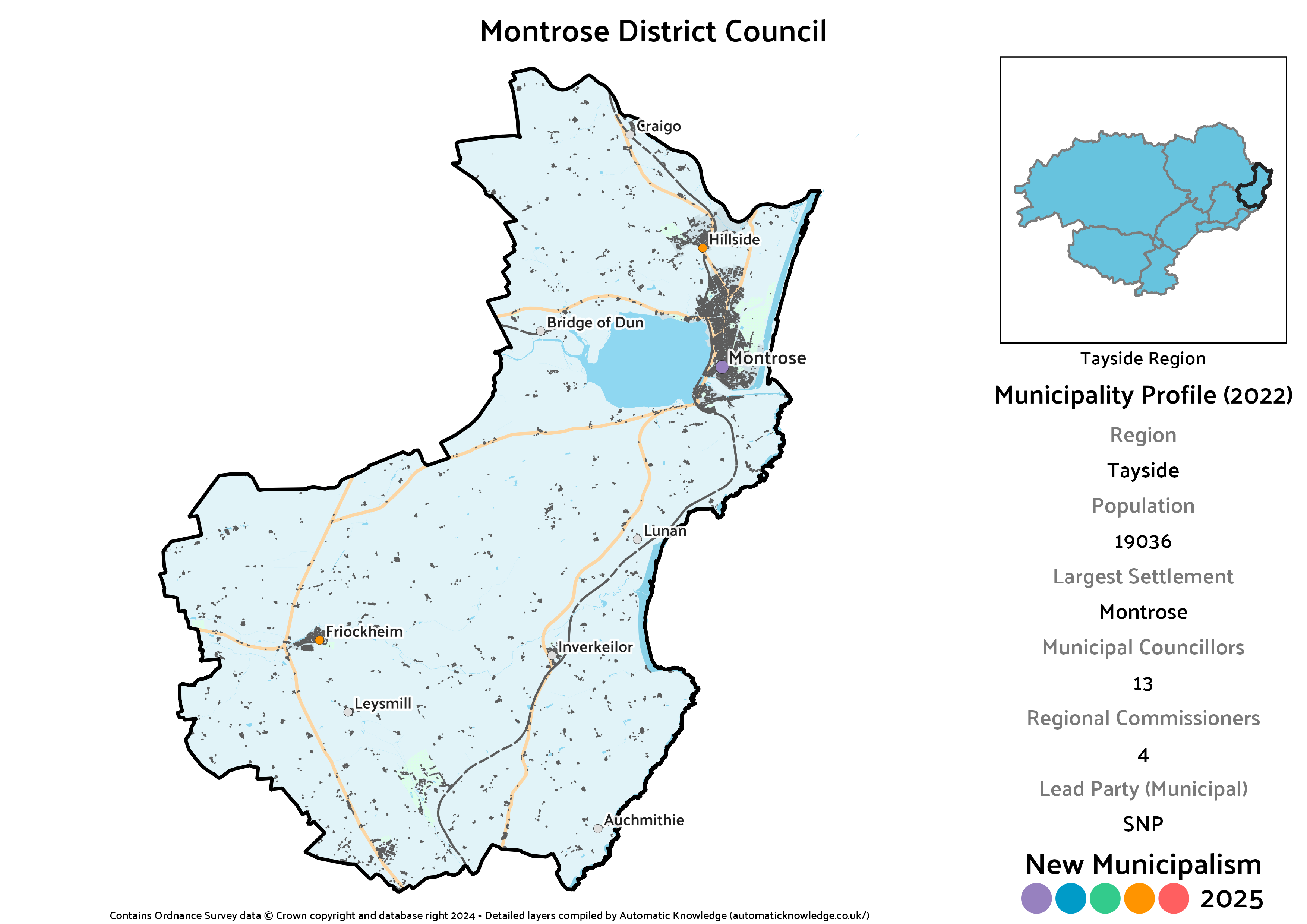
Key Statistics
Population: 19,036
Largest Settlement: Montrose
Municipal Councillors: 13
Regional Commissioners: 4
Description
Covering the northern portion of the Angus coast, this district is naturally centred on Montrose, by far the largest settlement in the area. The neighbouring village of Hillside and the more inland village at Friockheim are the next largest, leaving the remainder of the population quite widely dispersed. That population actually comes in almost a full thousand short of the 20,000 threshold, which is broadly fine for this part of the country, but was a surprise. The data I’d used before the Census dropped had something like another 2,000 residents here, which would have been more comfortably sized.
The SNP take the lead in this district, with the normal-for-Angus second placing for the Conservatives. Also in line with the local norm would be two Independents who both contested the Montrose and District ward in the real elections, Tommy Stewart (successful) and Mark Salmond (unsuccessful). Labour and the Lib Dems win a single seat, whilst the Greens cross the threshold but narrowly miss out.
Projected Municipal Election Results (2022)
Votes
Seats
Projected Regional Election Results (2022)
Votes
Seats
Perth City
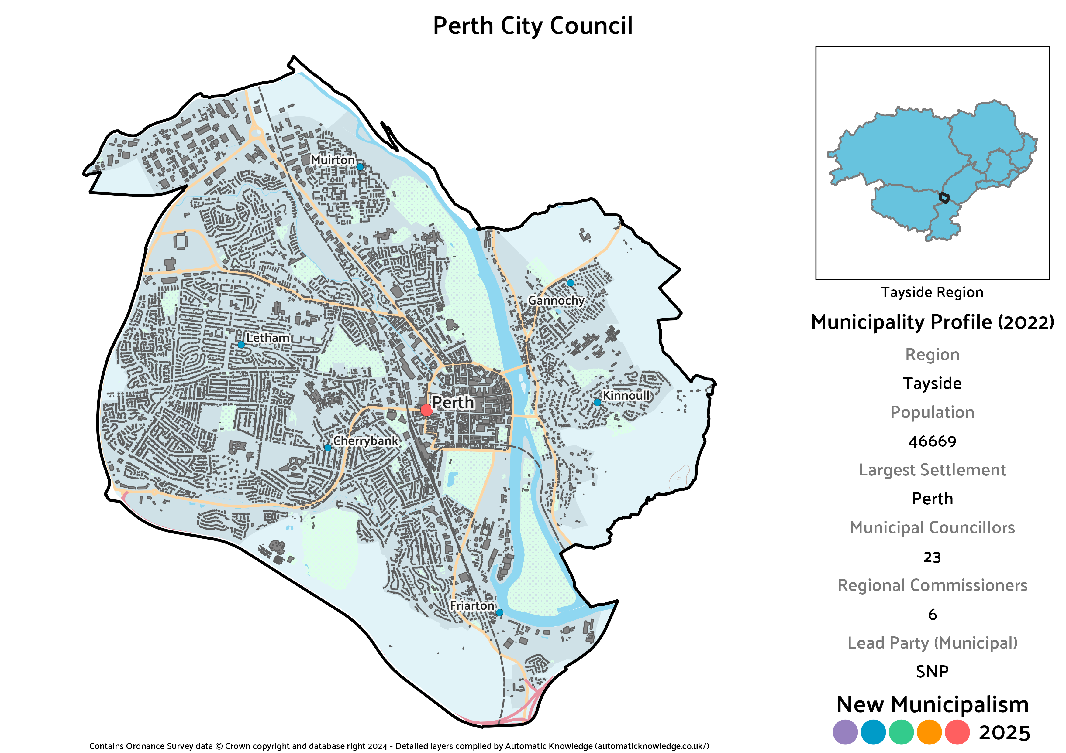
Key Statistics
Population: 46,669
Largest Settlement: Perth
Municipal Councillors: 23
Regional Commissioners: 6
Description
The smaller of the two cities in the region, Perth is either a relatively recent addition to Scotland’s crop of cities (being so titled in 2012), or a truly ancient one (that had that status unfairly stripped in the 1973 Act). Regardless, under our current local government structures, such titles are laughable little baubles when the city in question isn’t even a self-governing unit. Even if Perth were “only” a town, it’s a big one by Scottish standards, and should clearly have its own council.
As you’d expect from a city, it’s the SNP with a clear lead here, ending up with twice as many seats as their two next closest competitors combined. That’s the Conservatives and Lib Dems in a dead heat, in what is the Lib Dems’ best municipality in the region, built on their significant local strength in the southwest of the city. Similarly befitting the city status, Labour and the Greens also have representation here, though it ends up the only city council that’s part of a wider region not to have any Green regional seats.
Projected Municipal Election Results (2022)
Votes
Seats
Projected Regional Election Results (2022)
Votes
Seats
Sidlaw and Carse of Gowrie District
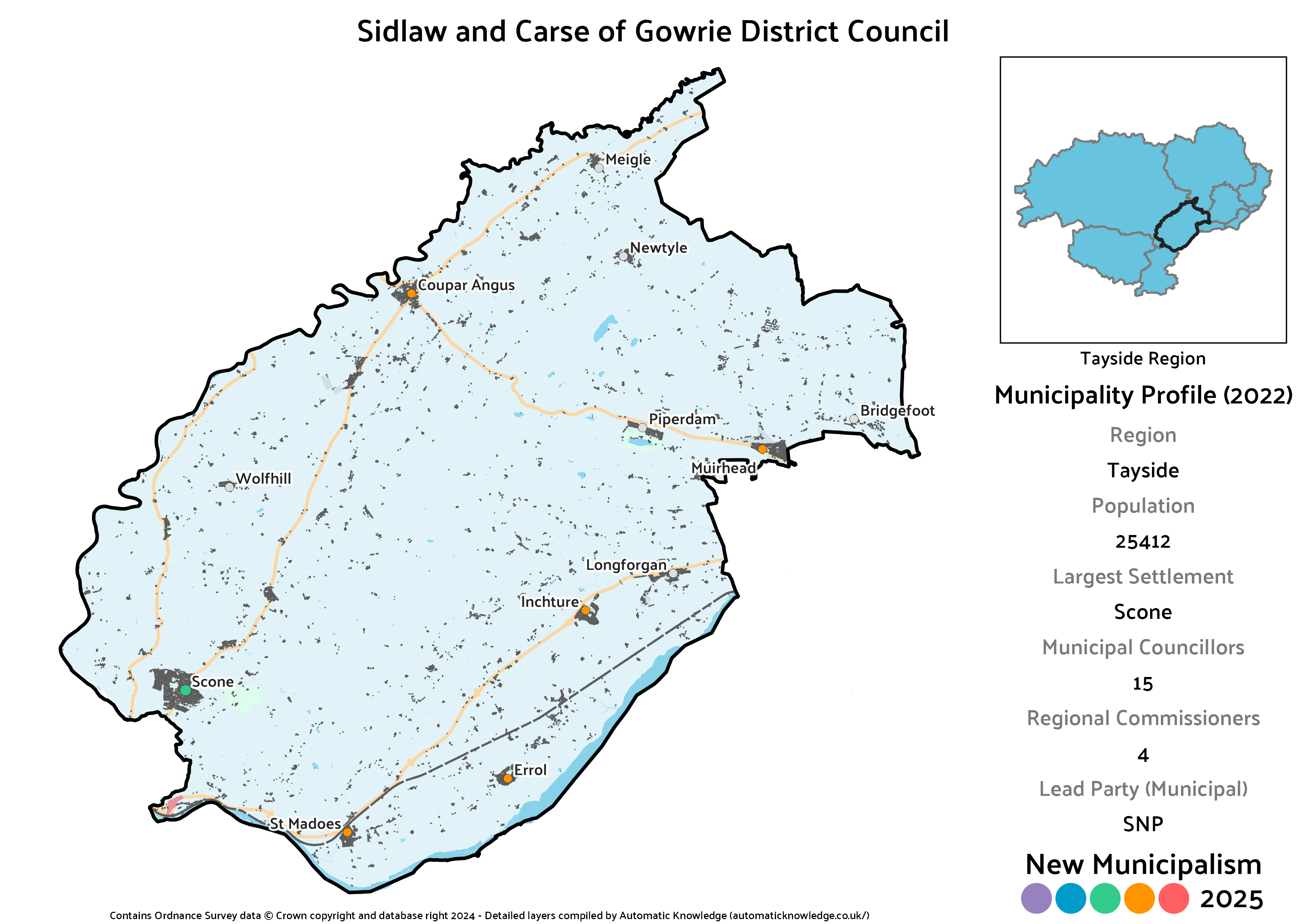
Key Statistics
Population: 25,412
Largest Settlement: Scone
Municipal Councillors: 15
Regional Commissioners: 4
Description
This is another one I have to admit I’m not brilliantly keen on. Bounded at either end by the two cities, with the Isla and the Tay as natural boundaries in the north and south, is in one respect quite neat. On the other hand, the Sidlaw hills do make for another rather obvious natural barrier, separating the Scone-Coupar Angus axis from the St Madoes-Longforgan line. Relative to the 2020 version, which was “Strathmore and Carse of Gowrie”, this has lost Invergowrie to Dundee, but gained the portion of Angus northwest of the city around Muirhead, Piperdam and Newtyle. Although that means breaking historic county lines, something I’ve often tried to do, you will note that Coupar Angus was already clipped out of Angus into Perthshire so long ago that it wasn’t even in Angus pre-1973, so there’s form for that locally.
The notional election results here are very close between the SNP and Conservatives, who tie in seats as a result. It’s also the best non-city municipality in the region for Labour, who have significant support in the actual Carse of Gowrie ward. The obligatory Independent presence for this one comes from Colin Stewart (elected in Strathmore), and decent enough support also sees the Lib Dems and Greens across the line for a seat each.
Projected Municipal Election Results (2022)
Votes
Seats
Projected Regional Election Results (2022)
Votes
Seats
Straths of Allan and Earn
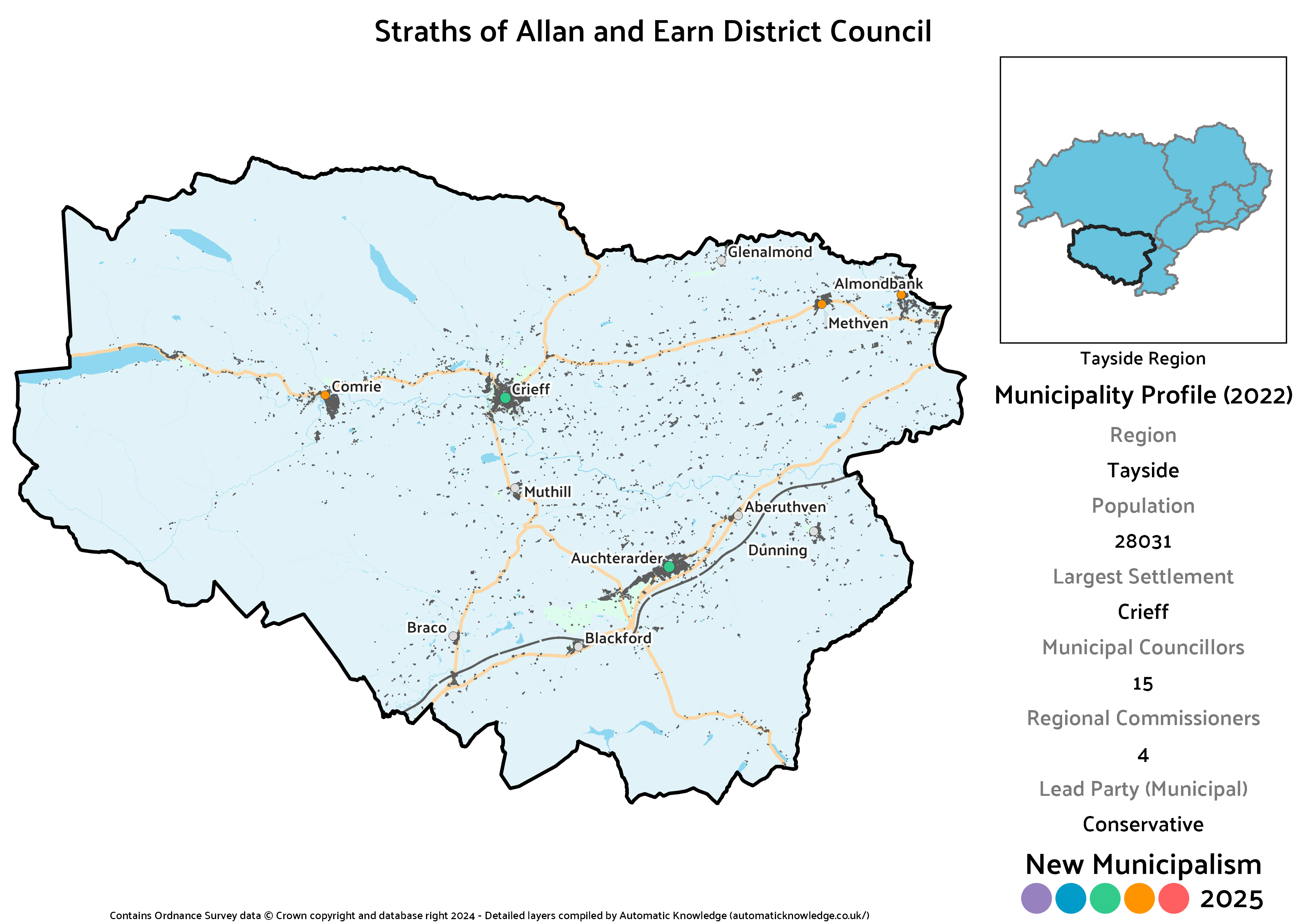
Key Statistics
Population: 28,031
Largest Settlement: Crieff
Municipal Councillors: 15
Regional Commissioners: 4
Description
As you might gather from the name, this is a district heavily defined by rivers. The Earn flows right through the middle, passing the largest town of Crieff as it does so. The Allan Water meanwhile rises not far from Auchterarder. Although it’s not in the name, the Almond also provides much of the northern boundary, until there’s a break to ensure that all of the Almondbank area is in one district.
Emphasising the Conservatives’ strength in southern Perthshire, this is their strongest municipality in the entire region, with the votes split falling just right to allow them to come just one seat short of a majority. Rhona Brock (elected in Strathearn) is the local Independent, and both the Lib Dems and Greens easily win a seat too. Notably, this is the only district in the region Labour didn’t contest any part of in 2022, so they show up absent at the municipal level as a result.