Region Overview
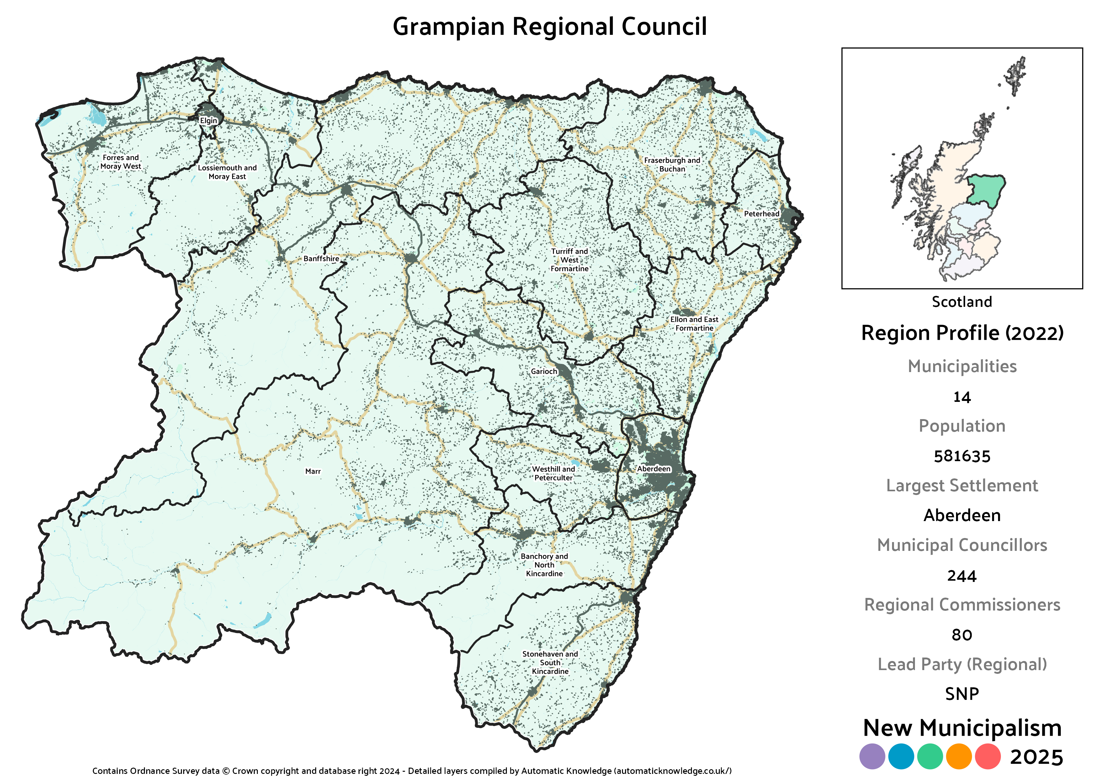
Key Statistics
Municipalities: 14
Population: 581,635
Largest Settlement: Aberdeen
Municipal Councillors: 244
Regional Commissioners: 80
Description
At the regional level at least, Grampian is a simple re-creation of the same region from the 1973 Act. It covers the entirety of that north eastern corner of Scotland, centred on the third largest city in the country, Aberdeen. At present this massive area is divided into just three local councils – Aberdeen City, Aberdeenshire and Moray. In the previous regional setup, Aberdeenshire was split into three districts, all of which are much larger than what I’m aiming for in this project. Historically speaking, this area was home to two further counties, Banffshire and Kincardineshire, which have since disappeared from the local government map.
Whilst the two largest cities in the country have been given Unitary Authority status in this project, Aberdeen is absorbed into this wider region. Whilst I’d expect Aberdeen to exert a substantial influence over Grampian as a whole, it isn’t utterly dominant. The population of the city is around 38% of the region, and its share of seats on the Regional Council is only 29% due to the weighting in favour of smaller municipalities. Overall though Grampian is without a doubt where the most sweeping changes have come compared to my 2020 version. Although just like last time there are 14 proposed municipalities, only two of those are largely unchanged. Everywhere else has had some degree of change, and some of those are pretty dramatic.
One point of potential awkwardness is what is currently the Moray Council area. Although it was included in the previous Grampian too, there’s perhaps a sense that at least the western portion of it (the bit that’s actually Moray) looks more to Inverness than to Aberdeen as a regional centre. I’ve opted to keep the whole area in, but it’s perhaps one to think about, especially bearing in mind most of the area of what is now Moray is actually the inland portion of Banffshire. It might – might! – be just about doable in terms of local identity to split between Grampian and Highland regions along those lines.
Politically, almost the entirety of Grampian has been hard fought between the SNP and Conservatives since the latter’s revival and the Lib Dem collapse. The general rule has been for the SNP to be strongest in urban areas and Conservatives in rural, which is why the Conservatives win more municipal councillors than the SNP despite fewer votes – they lead in 8 of the 6 municipalities, and since smaller municipalities have more councillors per head, that tips the balance. Nonetheless, the SNP tie them for seats on the regional side of things. Although weakened the Lib Dems remain reasonably strong across most of the region so place third overall, whilst Labour are near enough absent outside the urban centres. The Greens could claim a decent presence across the region, and would have an even better one if they’d contested more wards, and Alba pick up one of their very few councillors here too.
Projected Overall Municipal Election Results (2022)
Votes
Seats
Projected Overall Regional Election Results (2022)
Votes
Seats
Note: Bear in mind that for the regional results on an individual municipality basis below, the final seat is allocated from a region-wide levelling process. This means that whilst the distribution of seats is correctly proportional across the whole region, that is not necessarily the case in an individual municipality. The party that won each municipality’s levelling seat is marked by an asterisk * next to their name on the Votes chart.
Aberdeen City
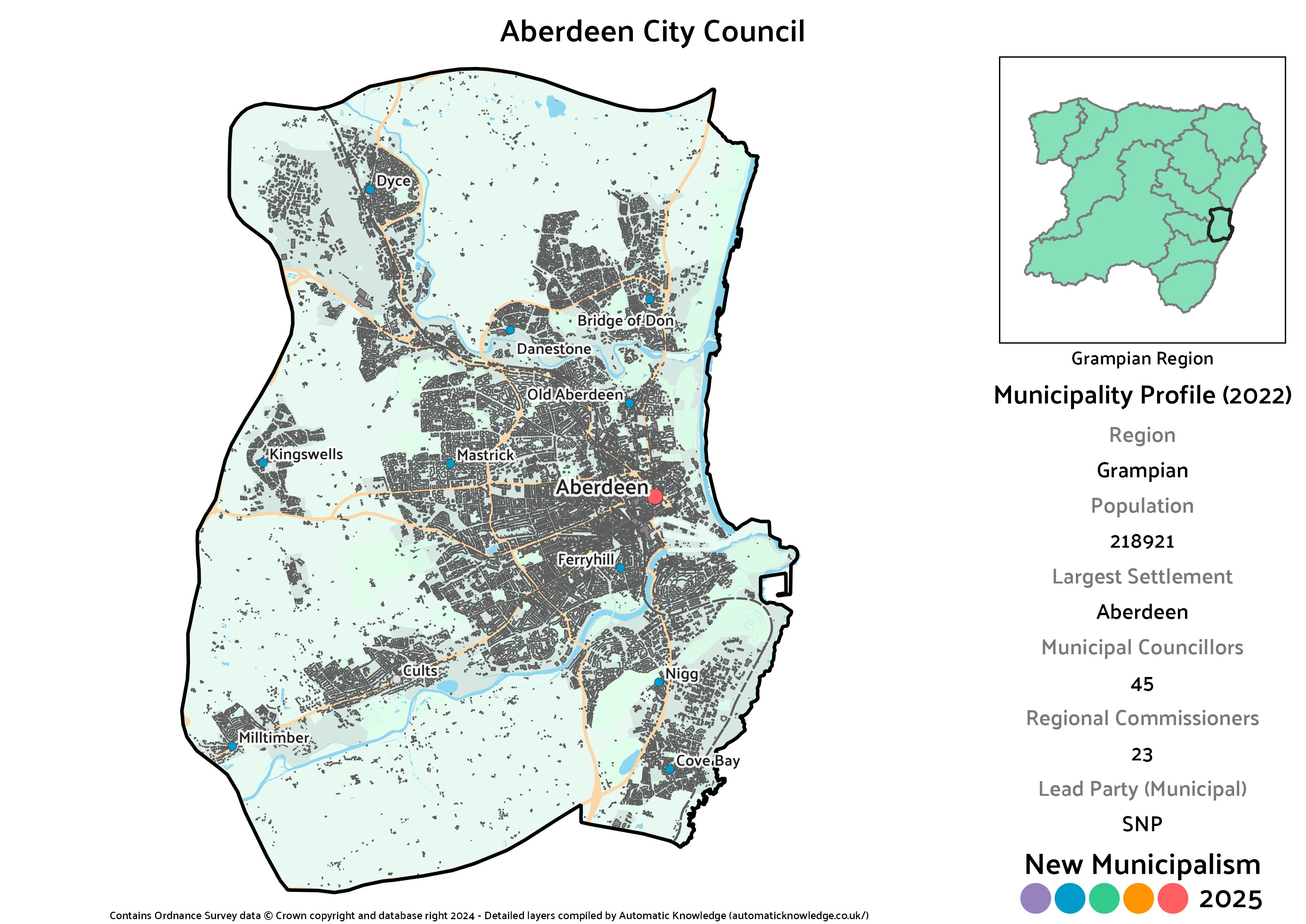
Key Statistics
Population: 218,921
Largest Settlement: Aberdeen
Municipal Councillors: 45
Regional Commissioners: 23
Description
Aberdeen already has its own City Council, and there’s no reason for that to change. As a major city, it was separated from its Shire well over a century ago when it became a “City and County”, effectively what we now call a Unitary Authority. When it was brought into the Grampian region under the 1973 Act, it expanded to take in areas the city had grown into including the Bridge of Don, Dyce, Cove Bay and Cults. It also pulled in some not-quite connected villages in Kingswells, Milltimber and Peterculter.
Compared to both the existing and the 2020 versions of the city, I’ve aligned the boundary to the Aberdeen Western Peripheral Route, which didn’t exist when the current boundaries were set. In most places this doesn’t actually have any meaningful population effect. What is quite big though is it snips Peterculter out of the city, as it’s on the wrong side of that road. Although that’s a rather significant change, bear in mind the whole regional council thing – it’s not the complete separation that would happen if these were unitary councils!
As is the norm across Scotland’s cities, the SNP would be the largest party here. Where Aberdeen differs is that it’s the only one of the Big Four current City Councils where the Conservatives would be second based on 2022 results. Labour and the Lib Dems would place relatively close to one another in third and fourth, whilst a pair of Greens would join Independent councillors Jennifer Stewart (Hazlehead, Queens Cross and Countesswells) and Marie Boulton (Lower Deeside) to round out the council. The real Aberdeen was a near miss for the Greens winning a seat, but also the only council with a formal cross-constitutional coalition, between the SNP and Lib Dems. They’d have the numbers for that in this scenario too.
Projected Municipal Election Results (2022)
Votes
Seats
Projected Regional Election Results (2022)
Votes
Seats
Banchory and North Kincardine District
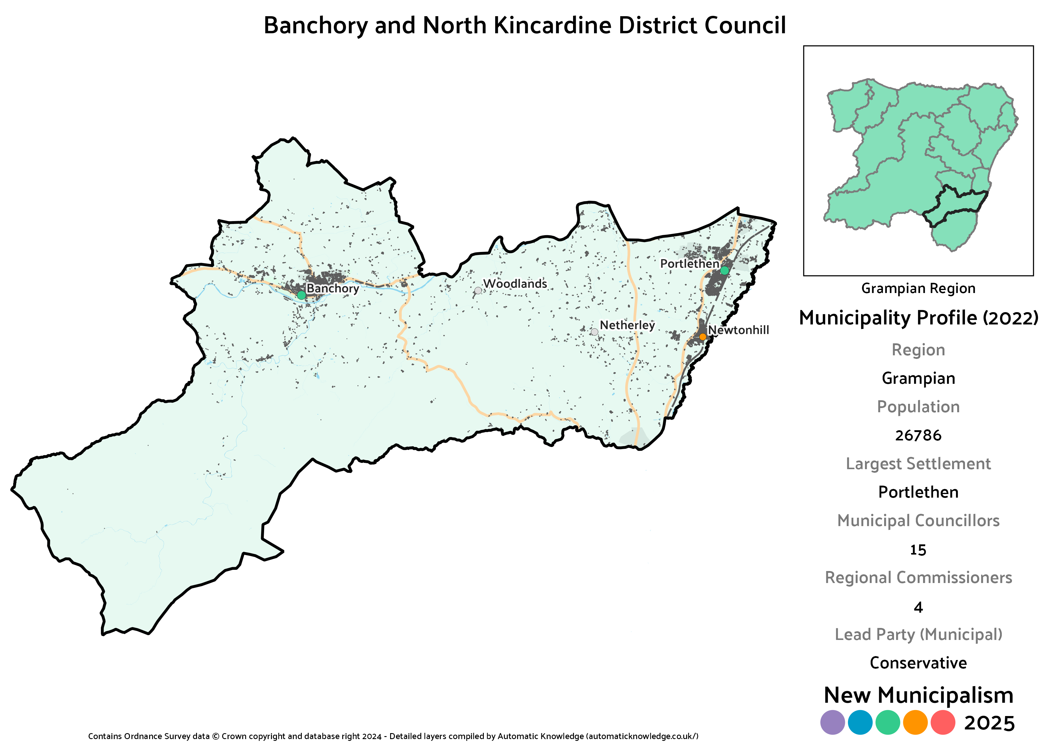
Key Statistics
Population: 26,786
Largest Settlement: Banchory
Municipal Councillors: 15
Regional Commissioners: 4
Description
One of the many big changes versus the 2020 version, Banchory and North Kincardine is a slightly awkward beast. In that previous attempt, Banchory had been included within the Marr district, but here I’ve largely aimed to restore the boundaries of the former Kincardineshire by combining that inland portion with the coastal stretch including Portlethen and Newtonhill. The road between the inland and coastal bits passes through other municipalities, but I don’t see that as a problem in and of itself. An alternative would be just making Kincardineshire a single district, but that would have a population of nearly 55,000, which rather goes against the principles of this project.
Although this follows the norm for the more rural Grampian districts in having a Conservative lead, it is one of their most narrow in the region. That’s still enough for a seat advantage over the SNP, whilst the Lib Dems and Labour pick up a pair of seats each. For Labour this is one of just two municipalities in the region outside of Aberdeen and Elgin where they squeak into double figures. The last seats would be rounded out by an Independent in Colin Pike (stood unsuccessfully in North Kincardine) and a Green, who like Labour are comparatively strong here.
Projected Municipal Election Results (2022)
Votes
Seats
Projected Regional Election Results (2022)
Votes
Seats
Banffshire District
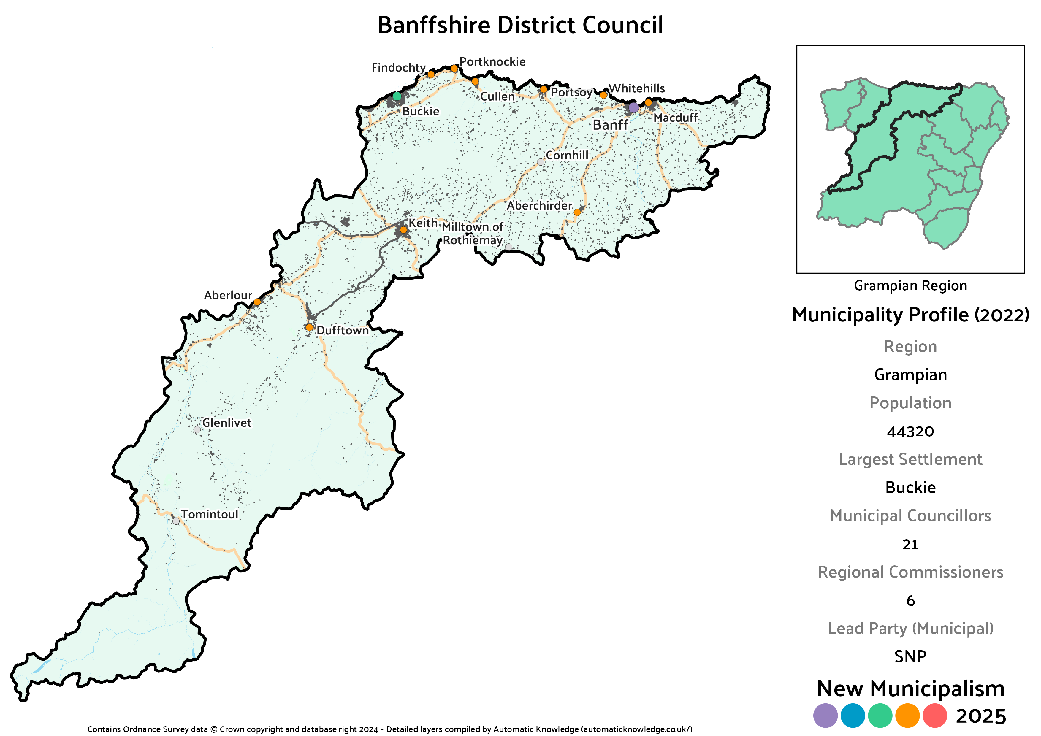
Key Statistics
Population: 44,320
Largest Settlement: Buckie
Municipal Councillors: 21
Regional Commissioners: 6
Description
When local government was redrawn in the 70’s, Banffshire was one of the counties most impacted. Not only did it cease to exist entirely, but whereas some other small counties were at least absorbed into new areas in full, Banffshire was split in two, between what are now the Moray and Aberdeenshire councils. In my 2020 version, I’d let that division stand and not really accounted for historic boundaries. This time around, Banffshire is back, back, back again, baby.
It is admittedly one of the oddest shaped areas, stretching from the coastal village of Gardenstown right into the heart of the Cairngorms, but most of the population lives in the string of coastal towns and villages which also include the likes of Buckie, Cullen, Macduff and Banff itself. The largest settlements inland are Keith, Dufftown and Tomintoul, but even allowing for a rural exemption from the strict 20,000 rule, I simply couldn’t get a split between coastal and inland components I was happy with, hence a rather large whole-county approach.
Politically, Banffshire comes out a bit split, with the SNP ahead by the tiniest bit at municipal level, and the Conservatives slightly further in front at regional. In both cases that gives the lead party a seat advantage over their closest competitor. Together they are completely dominant, as whilst the other three major parties plus an Independent (John Cox, Banff and District) all have seats, they’d all be lone councillors rather than groups. Despite that dominance, Labour do pick up one of the regional commissioners purely thanks to the levelling mechanism.
Projected Municipal Election Results (2022)
Votes
Seats
Projected Regional Election Results (2022)
Votes
Seats
Elgin Burgh
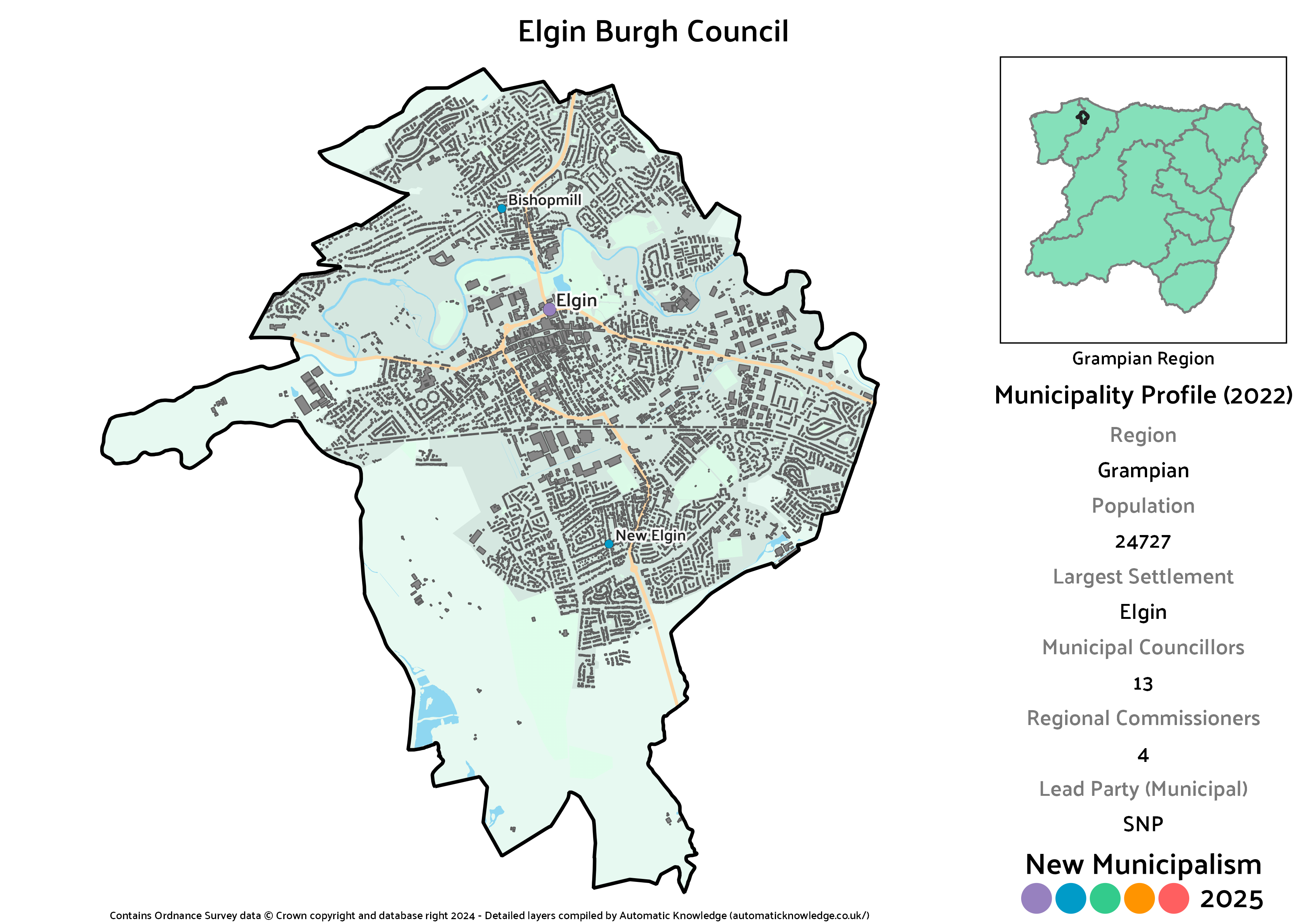
Key Statistics
Population: 24,727
Largest Settlement: Elgin
Municipal Councillors: 13
Regional Commissioners: 4
Description
Elgin is one of the largest towns in the north of Scotland, and would easily qualify for its own burgh in this project. Indeed, it would be the most northerly municipality not to be a District or Island council. Some might argue it was historically one of Scotland’s cities due to having once had a major cathedral, but as much as the council may try with the “Elgin City” ward names, that’s not a basis upon which to deem something a city in the 21st century, sorry.
As per the norm for urban Scotland, it’s the SNP that would come out in front here. Unlike the rest of the region though it’s Labour in second, with their best share anywhere in Grampian, though only a little bit ahead of the Conservatives in third. The number of seats up for grabs mean that by quirk of arithmetic, the difference in votes amounts to nothing – all three parties end up equal on seats. That leaves the last seat for the Greens, as none of the Independents beat them and although the Lib Dems also cross the threshold, it’s not enough when there are only 13 seats available (a good by-election result here in late 2024 would suggest imaginary success for 2027 though).
Projected Municipal Election Results (2022)
Votes
Seats
Projected Regional Election Results (2022)
Votes
Seats
Ellon and East Formartine District
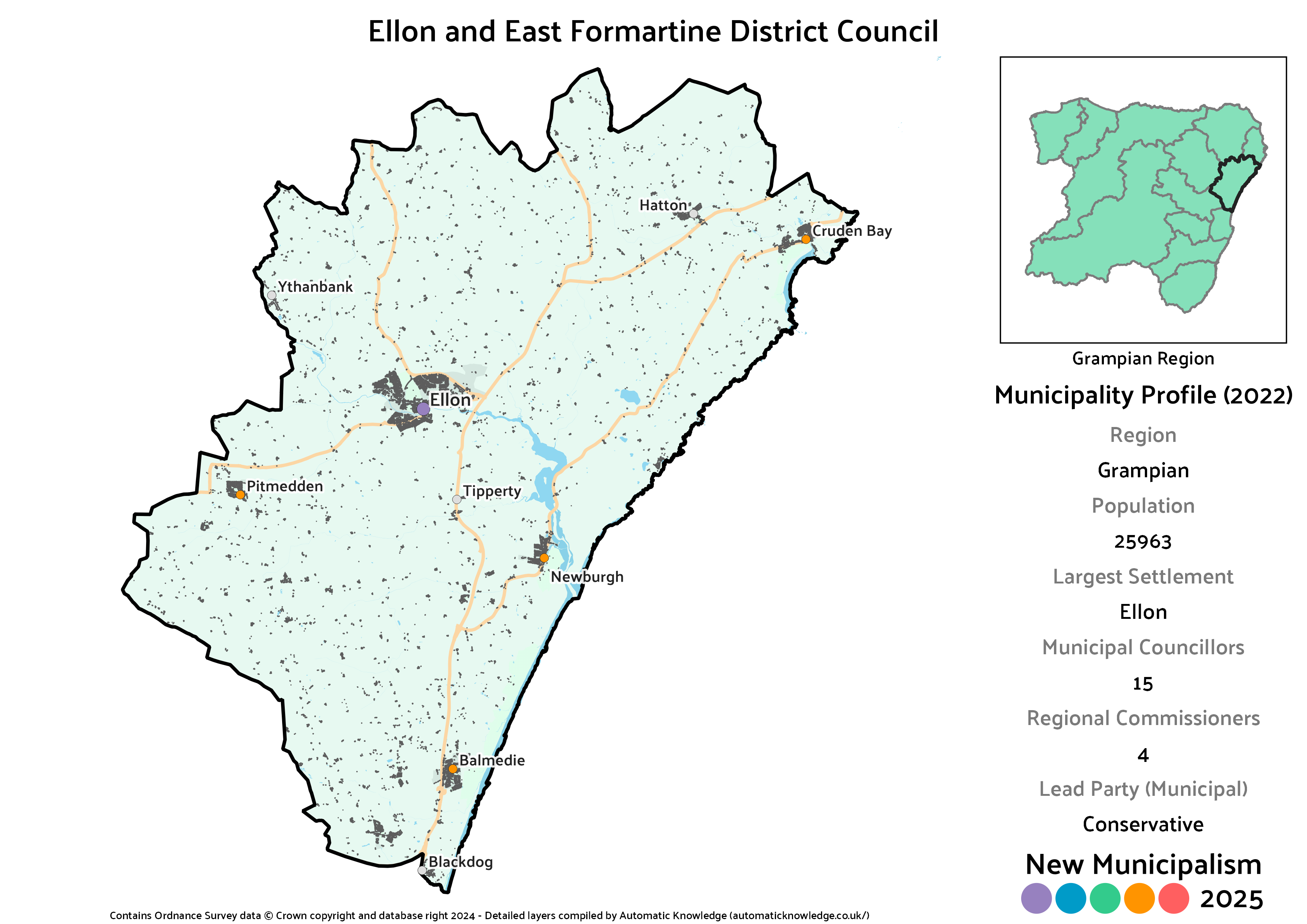
Key Statistics
Population: 25,963
Largest Settlement: Ellon
Municipal Councillors: 15
Regional Commissioners: 4
Description
By Aberdeenshire standards Ellon is a big town, and serves as the anchor for the more rural parts of this district. In the 2020 version, this included Newburgh, Balmedie, Blackdog and Ythanbank. This time around there’s an expansion both inwards, to Pitmedden, and along the coast to Cruden Bay. I think the latter may technically be breaking into the realms of Buchan, but it’s not like the Grampian area has a long history of consistency in those kinds of boundaries.
The Conservatives beat the SNP in the municipal vote by the tiniest of margins, which isn’t enough to take a seat advantage, and the SNP end up with more regional commissioners due to the levelling system. The Lib Dems perform very well here too, narrowly placing as their second best municipality in the region, whilst both Labour and the Greens pick up a single seat.
Projected Municipal Election Results (2022)
Votes
Seats
Projected Regional Election Results (2022)
Votes
Seats
Forres and Moray West District
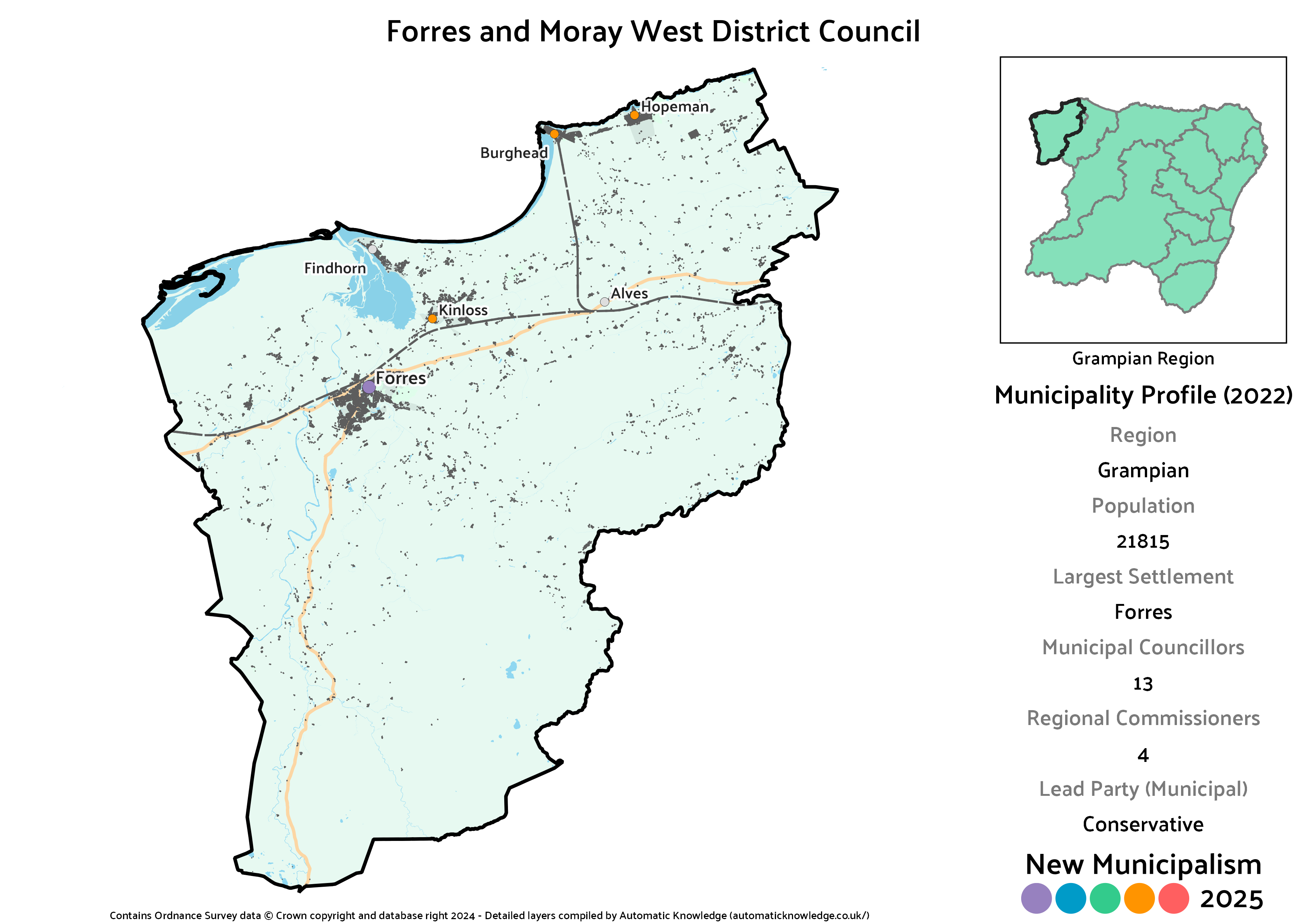
Key Statistics
Population: 21,815
Largest Settlement: Forres
Municipal Councillors: 13
Regional Commissioners: 4
Description
As the name implies, this covers the west of the traditional Moray area centred on Forres, also including Kinloss, Burghead, Hopeman and the odd little eco-village at Findhorn. The River Lossie defines most of the eastern boundary of this district, and that’s where there’s a notable difference compared to the 2020 version. That had drawn entirely on ward boundaries so didn’t extend quite as far as the river, whilst also including Lossiemouth. As part of the general reconfiguration this time around, Lossiemouth has been taken out.
In their second best part of the region the Conservatives have a strong enough lead in votes that, when combined with the exact split in votes, means they come up one shy of a majority on the district council. In second place the SNP are the only other party to elect more than a single councillor, as one apiece for an Independent (John Cowe, Heldon and Laich), Labour and the Greens. The Greens won a councillor in Forres in reality, and the fact it’s their second best municipality in Grampian sees them pick up one of the regional seats too thanks to the levelling process.
Projected Municipal Election Results (2022)
Votes
Seats
Projected Regional Election Results (2022)
Votes
Seats
Fraserburgh and Buchan District
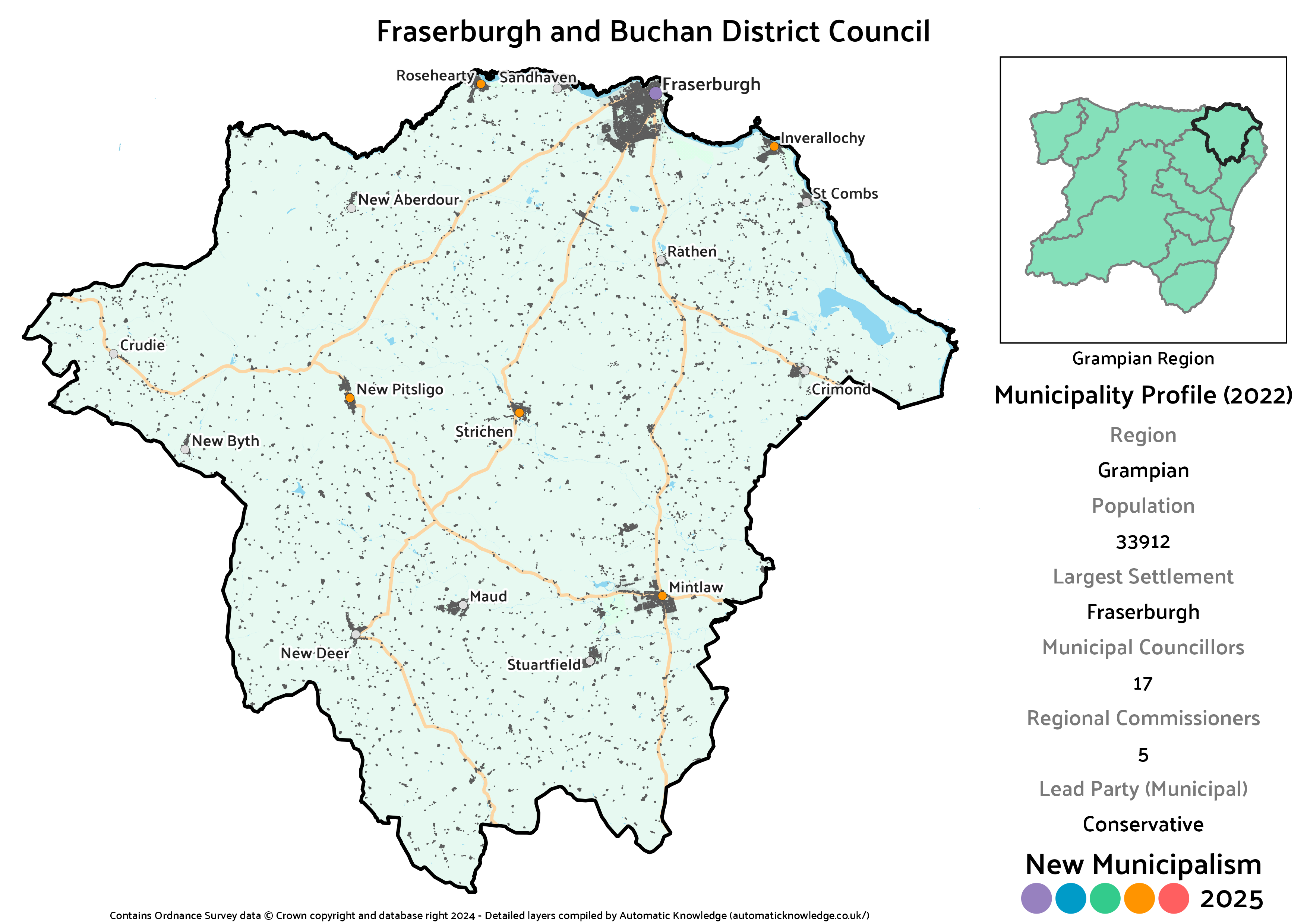
Key Statistics
Population: 33,912
Largest Settlement: Fraserburgh
Municipal Councillors: 17
Regional Commissioners: 5
Description
Yet another one of the drastic changes compared to the 2020 run at this project. In that version, Fraserburgh and Rosehearty had been paired with Macduff in a relatively narrow coastal district. As this time around I’ve restored the historic boundaries of Banffshire, I’ve looked elsewhere for a partner to Fraserburgh in the form of most of inland Buchan, including Strichen, Mintlaw, and New Pitsligo. In retrospect I really didn’t like my Buchan District from last time as it covered a lot of very small towns with no clear centre. I think this creates a much neater district, with all of the major roads here radiating from Fraserburgh.
It’s a very clear lead for the Conservatives here over the SNP, in the latter’s second weakest part of Grampian. Independents also garnered a chunky share of the vote, which would have seen Doreen Mair (actually elected in Fraserburgh and District) and Norman Smith (lost his seat in Central Buchan) over the line. The Lib Dems and Labour each pick up a sole councillor, as do Alba, in one of just a handful of municipalities across the country. Although the Greens look like they hit the 3% threshold which would land them a seat, especially given the excess of Independent votes, it’s actually 2.96%, so they come up short.
Projected Municipal Election Results (2022)
Votes
Seats
Projected Regional Election Results (2022)
Votes
Seats
Garioch District
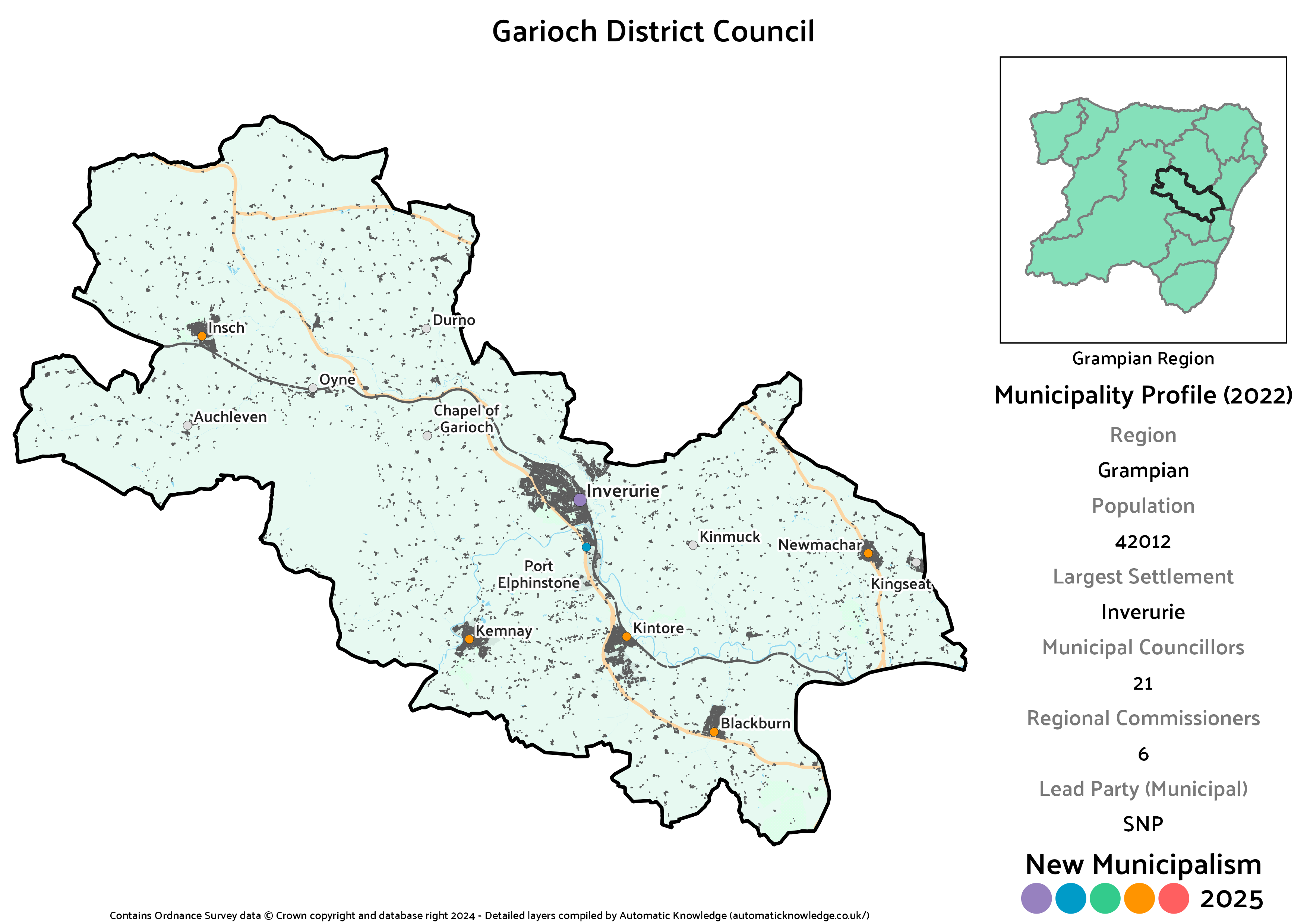
Key Statistics
Population: 42,012
Largest Settlement: Inverurie
Municipal Councillors: 21
Regional Commissioners: 6
Description
Again, this is a really big change compared to the 2020 version of the project, when the Garioch area had been split East and West based on combining entire Aberdeenshire Council wards. Garioch is still split in two this time around, but this version contains much more of the area, and is a lot less oddly shaped. Inverurie acts as the clear centre here, as it was in 2020’s Inverurie and West Garioch. Kemnay plus the area to the west of Inverurie, out to Insch, are similarly drawn from that one. The additions here are Kintore and Blackburn, lying on the main route out of Aberdeen, plus the somewhat detached villages of Newmachar and Kingseat.
The inclusion of the East Garioch ward is partly what results in this being the strongest SNP lead in a District council in Grampian, strong enough that it holds even at the regional level. The Conservatives are nonetheless not too far behind in second, and the sum of Independents is third in vote terms. That gives two councillors, Judy Whyte (elected in Inverurie and District) and Sheena Lonchay (unsuccessful in West Garioch), behind the 3 for the Lib Dems arising partly from so many Independent votes going spare. Labour get a second seat, probably for the same reason, leaving the Greens as the only group of one. The relatively large population of this district also helps Labour pick up a regional seat through the levelling mechanism.
Projected Municipal Election Results (2022)
Votes
Seats
Projected Regional Election Results (2022)
Votes
Seats
Lossiemouth and Moray East District
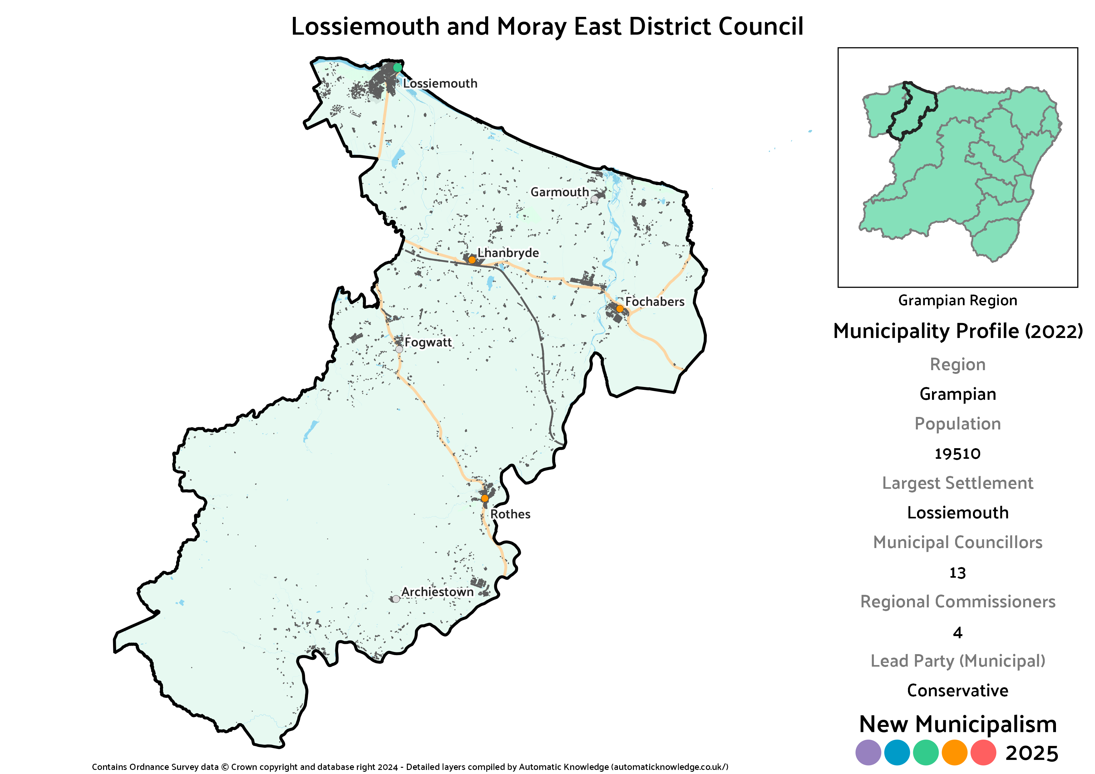
Key Statistics
Population: 19,510
Largest Settlement: Lossiemouth
Municipal Councillors: 13
Regional Commissioners: 4
Description
Last time around, I’d made the eastern portion of the current Moray council area less the coastal stretch at Buckie into “Speyside Central”. Having restored the historic boundaries of Banffshire this time, I’ve similarly pulled Moray largely back within its own traditional boundaries, whilst also drawing Lossiemouth in. The boundaries here therefore largely end up defined by rivers, with the River Lossie in the west up until it hits Elgin, and the River Spey in the east until just before Fochabers. I don’t know why historic Moray spilled across the Spey at that point, but it’s helpful for population numbers here, as this falls just short of the normal threshold, even if I find it geographically irritating.
The Conservatives would have a modest lead in this one in 2022 terms, though with the SNP close enough behind to come equal in seats on the district council. In third place, their highest placing and strongest vote in the region, would be the Greens, driven by a strong result in the Speyside Glenlivet ward in reality plus transfers from Independents that I’ve excluded from the count here due to them having more votes on the other side of their split wards. That only lands them the one councillor, same as Labour and the Lib Dems, but it does secure them a regional commissioner to boot thanks to levelling seats.
Projected Municipal Election Results (2022)
Votes
Seats
Projected Regional Election Results (2022)
Votes
Seats
Marr District
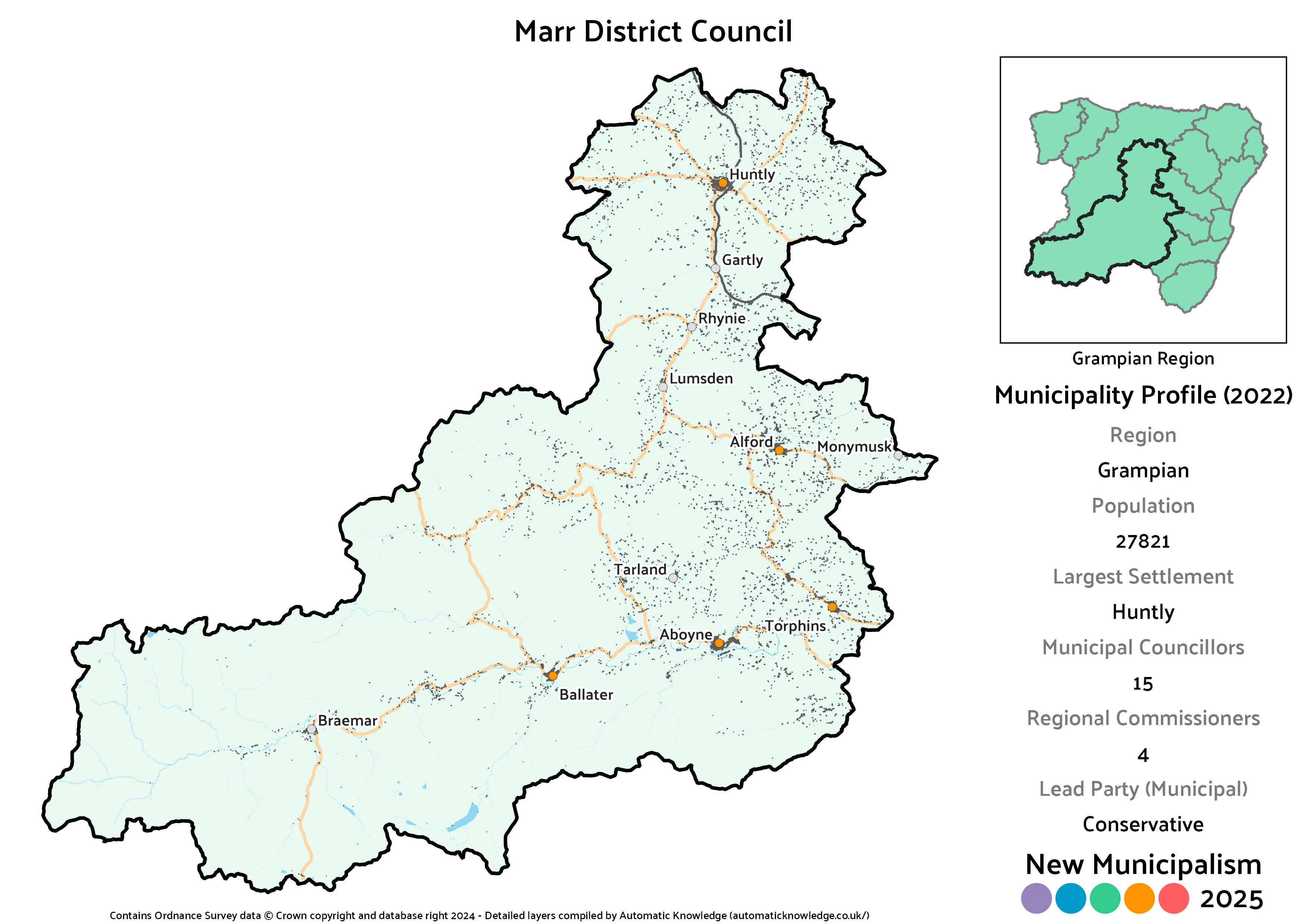
Key Statistics
Population: 27,821
Largest Settlement: Huntly
Municipal Councillors: 15
Regional Commissioners: 4
Description
Drawing it’s name from one of the current Aberdeenshire Council’s Committee Areas, traditionally speaking Marr was a relatively thin strip that would have stretched from Braemar through Ballater and Aboyne and out to the sea. The modern definition used by the council extends quite significantly northwards to also include Alford and Huntly. Differing again from both the current committee area definition and the 2020 version of this project, this doesn’t include the portion around Banchory, which has been shifted to allow the partial recreation of Kincardineshire. This is therefore a smaller, though still pretty massive, inland expanse.
This is pretty fertile ground for the Conservatives, coming out as their best municipality in the Aberdeenshire portion of the region. It’s not terrible for the SNP, though despite a significant vote lead the split of votes comes out at only one seat ahead of the Lib Dems, who also perform pretty well here. The remaining two seats would be taken up by Geva Blackett (who was elected in Aboyne, Upper Deeside and Donside) and a single Labour councillor.
Projected Municipal Election Results (2022)
Votes
Seats
Projected Regional Election Results (2022)
Votes
Seats
Peterhead Burgh
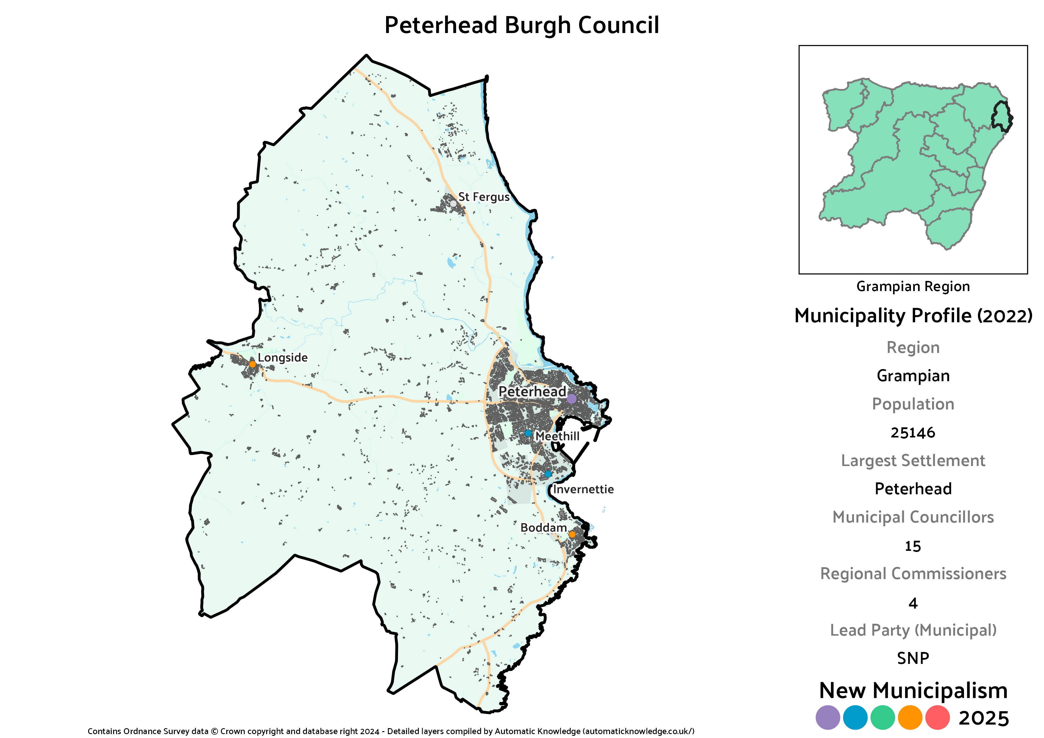
Key Statistics
Population: 25,146
Largest Settlement: Peterhead
Municipal Councillors: 15
Regional Commissioners: 4
Description
Aberdeenshire has a pretty hefty population, but it’s comparatively thinly spread, meaning Peterhead is the only town large enough to qualify for its own burgh council. Compared to the 2020 run at this project, it’s actually extended a little bit beyond the town. Boddam was already included then, but this time it also stretches out to Longside in the west and St Fergus in the north, mostly just to tie them closer to a major town.
As you might expect for a burgh council, it’s the SNP coming out on top at the municipal level here. That squeaks to a two seat advantage over the Conservatives (7 more votes for the latter would have made it an even split) who end up the stronger party on the regional side of things. That’s driven in large part by the divvying up of votes from the two Independents, Dianne Beagrie (a former Conservative) and Alan Buchan, who were both elected to the Peterhead North and Rattray ward in 2022. A little bit of extra political colour is provided by a solitary Lib Dem, with neither Labour nor the Greens having contested either ward at the real election.
Projected Municipal Election Results (2022)
Votes
Seats
Projected Regional Election Results (2022)
Votes
Seats
Stonehaven and South Kincardine District
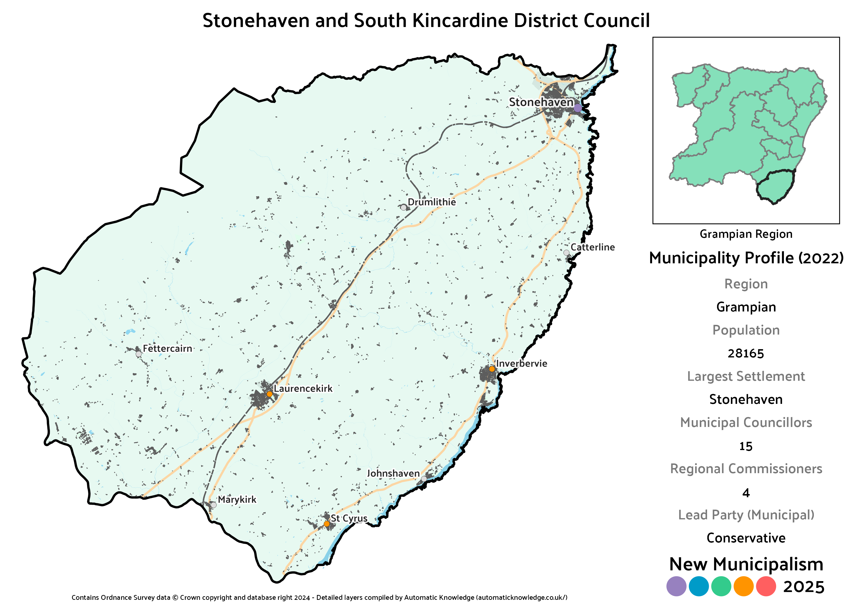
Key Statistics
Population: 28,165
Largest Settlement: Stonehaven
Municipal Councillors: 15
Regional Commissioners: 4
Description
Stonehaven and South Kincardine basically is exactly what it says on the tin, covering all of the traditional county of Kincardineshire from Stonehaven southwards. That includes Inverbervie and Laurencekirk as major settlements, plus smaller villages like St Cyrus, Fettercairn and Catterline. In the 2020 version, a Stonehaven-anchored district had included coastal Kincardine all the way up to the border with Aberdeen City, but was trimmed down a bit this time.
There’s a really very lovely 5-4-3-2-1 pattern on the imagined district council here, with Conservatives leading the SNP, then three Independents – Alison Evison (elected in Mearns), Dave Stewart (unsuccessful in Mearns) and Ma Simpson (unsuccessful in Stonehaven and Lower Deeside). That leaves the Lib Dems and Labour in the last two spots, with the Greens crossing the threshold but not with enough votes to actually win a seat. Labour may be weak outside of the two biggest settlements in Grampian, but this is comparatively strong for them so it’s where they pick up a regional seat thanks to the levelling system.
Projected Municipal Election Results (2022)
Votes
Seats
Projected Regional Election Results (2022)
Votes
Seats
Turriff and West Formartine District
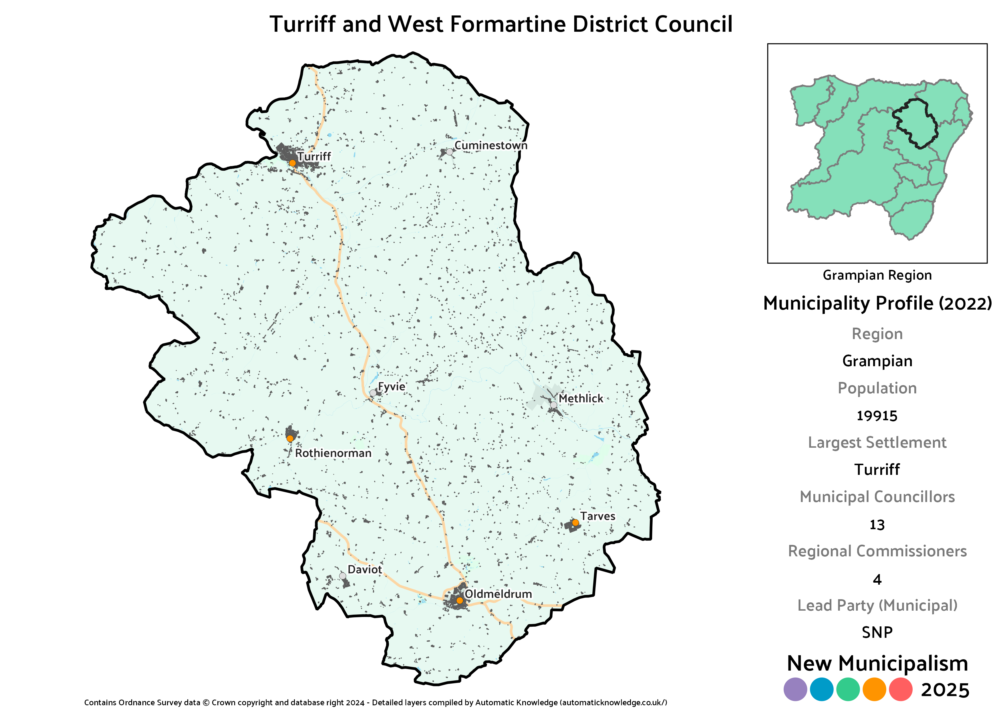
Key Statistics
Population: 19,915
Largest Settlement: Turriff
Municipal Councillors: 13
Regional Commissioners: 4
Description
Covering a large stretch of inland Aberdeenshire, the western portion of Formartine has two major settlements at its edges – Turriff in the north, and Oldmeldrum in the south. Both were historically burghs, but are far too small for that status in this project. In addition, smaller villages scattered across the area include Rothienorman, Tarves, Cuminestown, Fyvie, Methlick and Daviot. A relatively minor change relative to my 2020 suggestion here in that Pitmedden was popped in the eastern Formartine district this time, which will be what tips this a tiny bit below the usual 20,000 marker – acceptable for a rural district though.
As per rural Aberdeenshire norm, it’s the Conservatives in front of the SNP here though tied in seats. The Lib Dems are also very strong here, their third best municipality in the region, whilst an Independent in the form of Paul Johnston (elected in Mid Formartine) keeps the Greens company in the solo councillor category, the latter just squeaking over the line.
Projected Municipal Election Results (2022)
Votes
Seats
Projected Regional Election Results (2022)
Votes
Seats
Westhill and Peterculter District
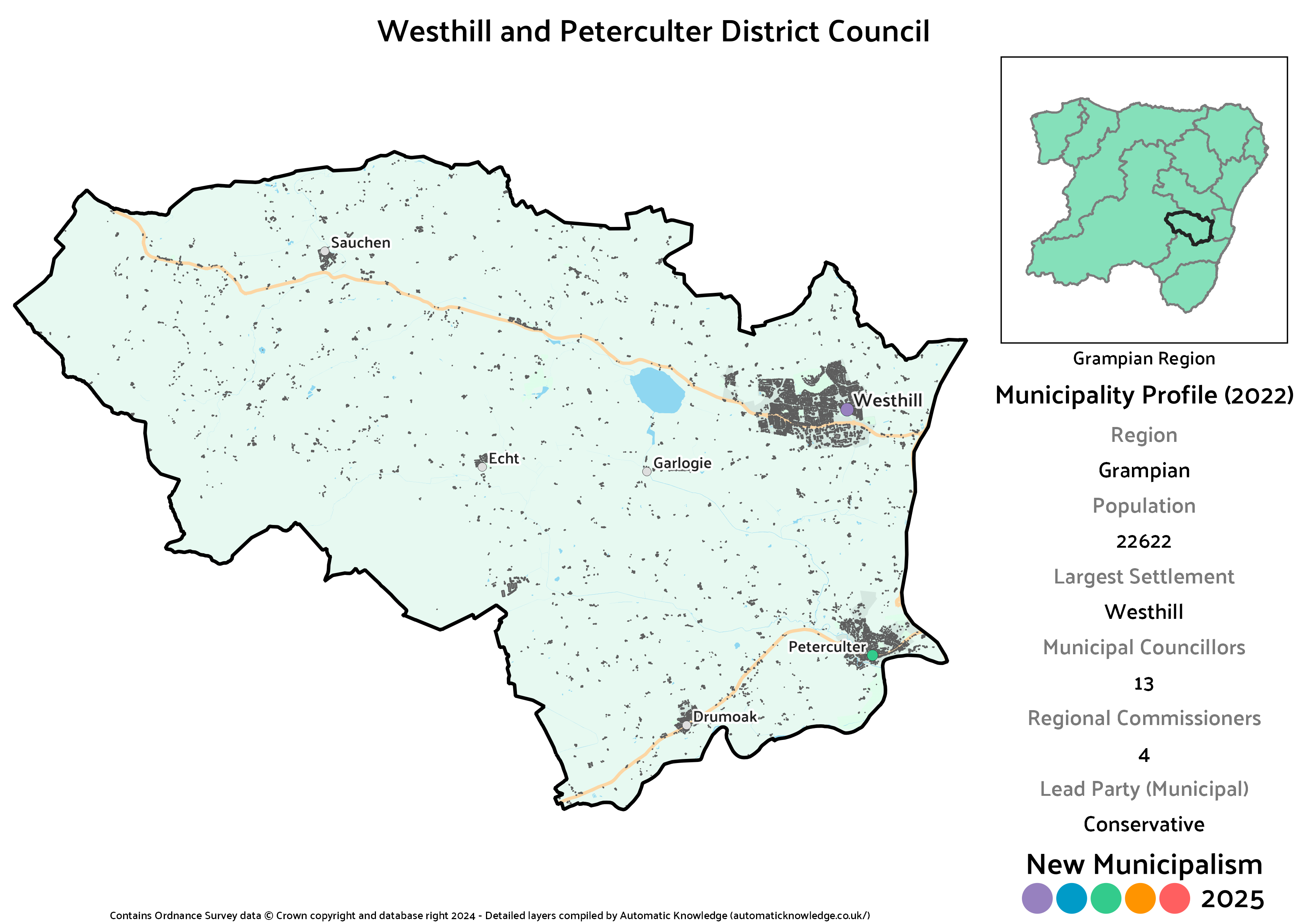
Key Statistics
Population: 22,622
Largest Settlement: Westhill
Municipal Councillors: 13
Regional Commissioners: 4
Description
One of the bigger changes since 2020, whereas Westhill had been the centre of an awkwardly shaped East Garioch district then, this time it pairs up with Peterculter, which has been chopped out of Aberdeen. It also draws in the village of Drumoak which had been in the Marr District. Effectively, this brings together the primary commuter towns and villages to the immediate west of Aberdeen, albeit that they exist on two separate spurs.
This is hands-down the worst municipality in the region for the SNP, giving the Conservatives their biggest lead but by no means their biggest vote share. Instead, it’s a very strong result for the Lib Dems (driven by Westhill) and Labour (driven by Peterculter) that account for much of that squeeze. It’s also the best bit of the Aberdeenshire centred districts for the Greens, though in reality that’s probably coming from the Peterculter bit.