Clyde Region Overview
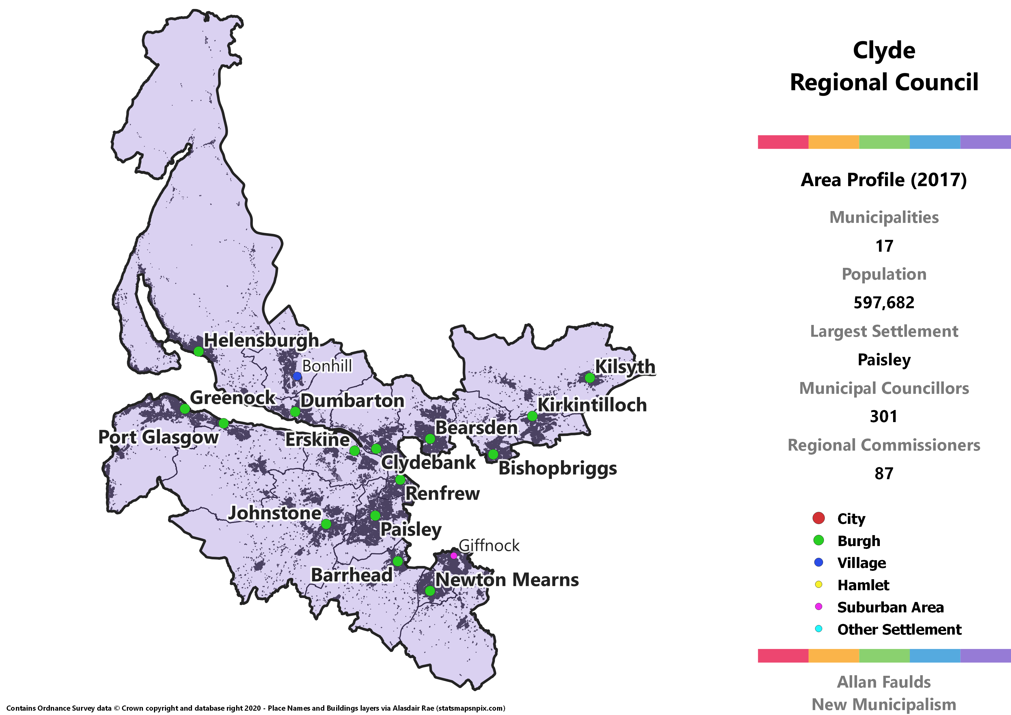
Key Statistics
Municipalities: 17
Population: 597,682
Largest Settlement: Paisley
Municipal Councillors: 301
Regional Commissioners: 87
Region Description
The proposed Clyde region can broadly be thought of as combining the historic counties of Dunbartonshire and Renfrewshire, with some minor additions and omissions. Although located on opposite banks of the Clyde and with Glasgow in the middle blocking some direct transport links, I reckon these two areas are similar enough both demographically and in terms of their strong links to that city to form a unified region. I can imagine it doing an Aberdeenshire and siting the HQ in Glasgow for convenience, though Paisley’d be awfae annoyed at that.
I’ve very strongly resisted the idea of annexing areas of these two counties to Glasgow, even though many of the towns here form a contiguous settlement with it. Given Scotland has a huge problem with over-sized local government, expanding our largest city is hardly going to be part of the solution. Doing so with all the joined-up areas would also effectively wipe both of these counties out of existence, something I (as a Dunbartonshire-born lad) am unwilling to do.
Similarly I’ve also avoided re-creating even a smaller version of the jumbo-region that was Strathclyde. There is a very strong case to be made for integrated systems of transport, healthcare, and tertiary education across the wider Glasgow conurbation. However, squeezing nearly two million people back into a region and calling it “local” shouldn’t be necessary for that. Instead, Regions and Municipalities should look towards improving on models like the Strathclyde Partnership for Transport (SPT).
The big omission from this proposal is Cumbernauld, which was historically the easternmost part of Dunbartonshire. It remained associated with that area even during the Strathclyde Regional Council days, only finally being packaged up with North Lanarkshire in 1994. Despite hiving Kilsyth off into this region, I’ve left Cumbernauld in Lanarkshire for now, though I have no strong objection to pulling it into Clyde.
Additions include small portions of current North Ayrshire, North Lanarkshire and South Lanarkshire. Although in this project I’ve not often broken both existing council and historic county lines, in each of these cases I think there’s a solid argument for doing so.
Overall, the areas making up the Clyde region have seen the SNP eclipse Labour, and strong support for the Conservatives in certain key areas then helped push Labour into third place here. In addition to the five Holyrood parties, there’s an interesting addition to the Regional council in the form of the West Dunbartonshire Community Party.
That party has such strength that, thanks to the ability of local parties to ignore the threshold, it actually picks up a seat when we extrapolate 2017 results. In reality, that is mostly the personal vote of one councillor in the Vale of Leven, and how replicable it would actually be in a genuine Clyde Regional Council election is debatable.
Barrhead and Neilston Burgh

Area Profile (2017)
Population: 24,111
Largest Settlement: Barrhead
Municipal Councillors: 13
Regional Commissioners: 4
Municipality Description
When the current boundaries of East Renfrewshire were being drawn up, Barrhead and Neilston ended up as an awkward bolt-on to what had previously been the Eastwood District. For one thing, there are relatively minimal transport links between the two sections. The train line to Neilston bypasses Barrhead (for now), there’s a whole country park in between the sections, and the main road between them actually goes through Glasgow rather than direct. Effectively, Barrhead and Neilston form their own distinct “spur” of settlement coming off Glasgow.
In addition, whilst much of the Eastwood area consists of affluent Glasgow suburbs, Barrhead and Neilston are more typically working class areas which aren’t contiguous with Glasgow. All of the SIMD 2016 top 20% most deprived areas in East Renfrewshire are in this portion – though it has its share of areas in the 20% least deprived too. That kind of demographic difference is likely to have a substantial impact on what local priorities are and what services are required.
This distinction shows quite strongly at local elections. In the area covered by this proposal, the SNP and Labour combined won around 57% of the vote at the 2017 local elections, against around 18% for the Conservatives. For the rest of East Renfrewshire, the combined SNP/Labour total was only about 36%, compared to circa 44% for the Conservatives. It is of course common for different areas to have their own unique voting patterns, but it’s rarely this stark.
The combination of all three of these things – geographic separation, differential deprivation, and political distinctions – make Barrhead and Neilston one of the best examples of how badly we currently do local government in Scotland. The area easily qualifies for its own council under my rules, and would have it in almost any other European country.
Note that in addition to Barrhead and Neilston this also includes the much smaller village of Uplawmoor, which sits on the same “spur”, and some of the surrounding rural area which just has to go somewhere. That means it would include a portion of the historic Eastwood area, though with a very small population.
Bearsden and Milngavie Burgh
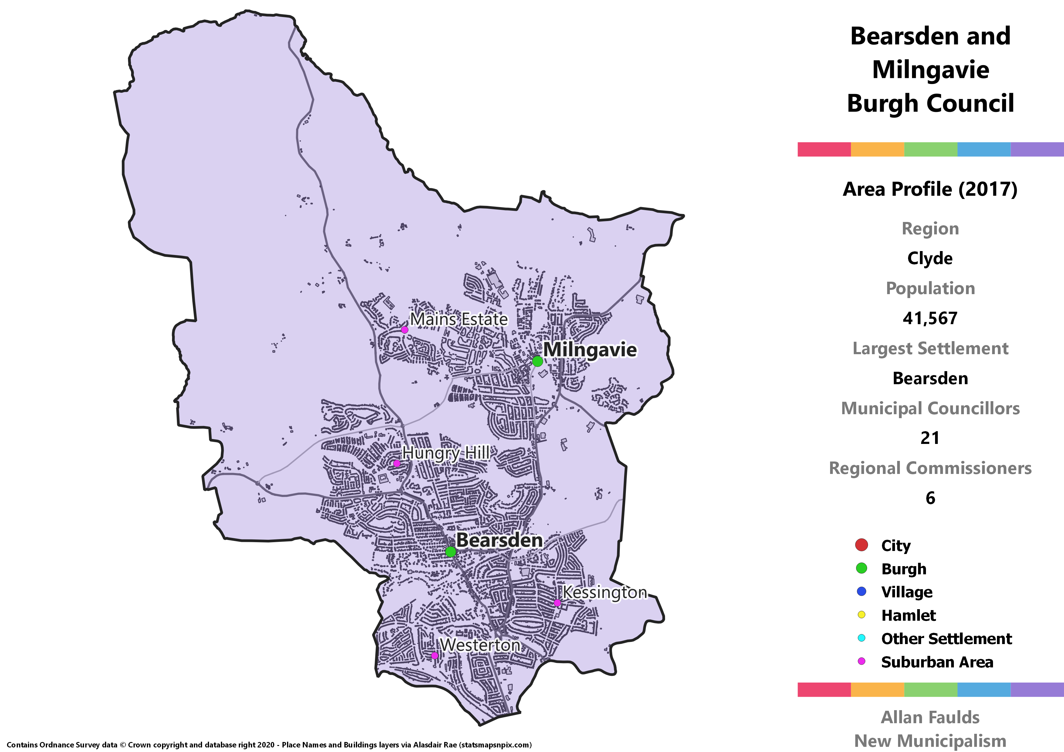
Area Profile (2017)
Population: 41,567
Largest Settlement: Bearsden
Municipal Councillors: 21
Regional Commissioners: 6
Municipality Description
This one is really neat and easy, effectively a like-for-like recreation of the 1973 Act’s Bearsden and Milngavie District. Although this project is aiming for more local units than that act did, these two towns are so well integrated it’d make no sense to split them, even if Milngavie wasn’t too small to stand alone.
The existing East Dunbartonshire council this currently part of is widely known to be one of the most affluent parts of Scotland. That’s most evident in Bearsden and Milngavie, which contains no areas in the SIMD 2016 top 20% most deprived. There are a handful of areas however, particularly in Milngavie, that are in the most deprived half.
Politically, Bearsden and Milngavie has the potential to be quite diverse. It’s one of the few places the simple extrapolation of actual 2017 results shows councillors from each of the 5 Holyrood parties, as well as Independents. It’s an almost even split between Conservative, Lib Dem and SNP councillors as well.
Bishopbriggs Burgh
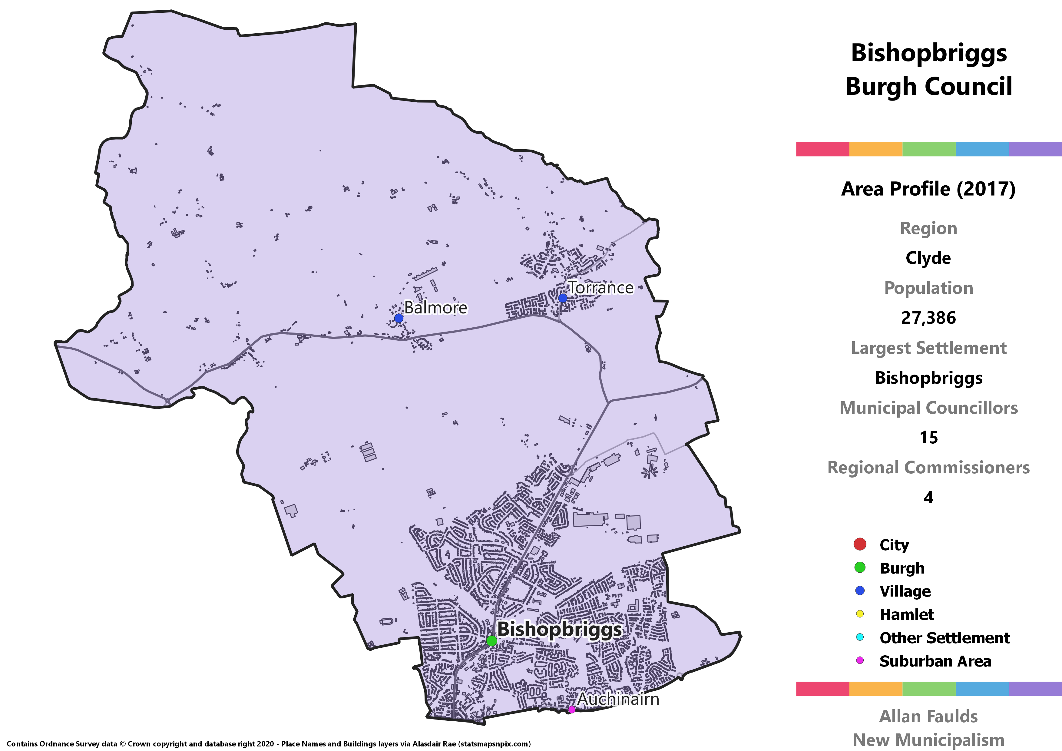
Area Profile (2017)
Population: 27,386
Largest Settlement: Bishopbriggs
Municipal Councillors: 15
Regional Commissioners: 4
Municipality Description
Bishopbriggs used to have its own Burgh council before the 1973 Act did away with them. This is a somewhat expanded recreation, as it also takes in a stretch of country to the north of the town itself. That most notably includes the villages of Torrance and Balmore, though their populations are small enough I felt this could remain Bishopbriggs Burgh rather than District. This area was part of a really awkward interface point between Glasgow, Lanarkshire, Dunbartonshire and Stirlingshire under the old county system, with Bishopbriggs in Lanarkshire and the villages in Stirling.
This is another affluent part of the existing East Dunbartonshire council area. Unlike its western neighbour however, it does have one bit in the most deprived SIMD quintile, with the Auchinairn area overall ranking as substantially more deprived than the rest of the burgh.
Campsie District
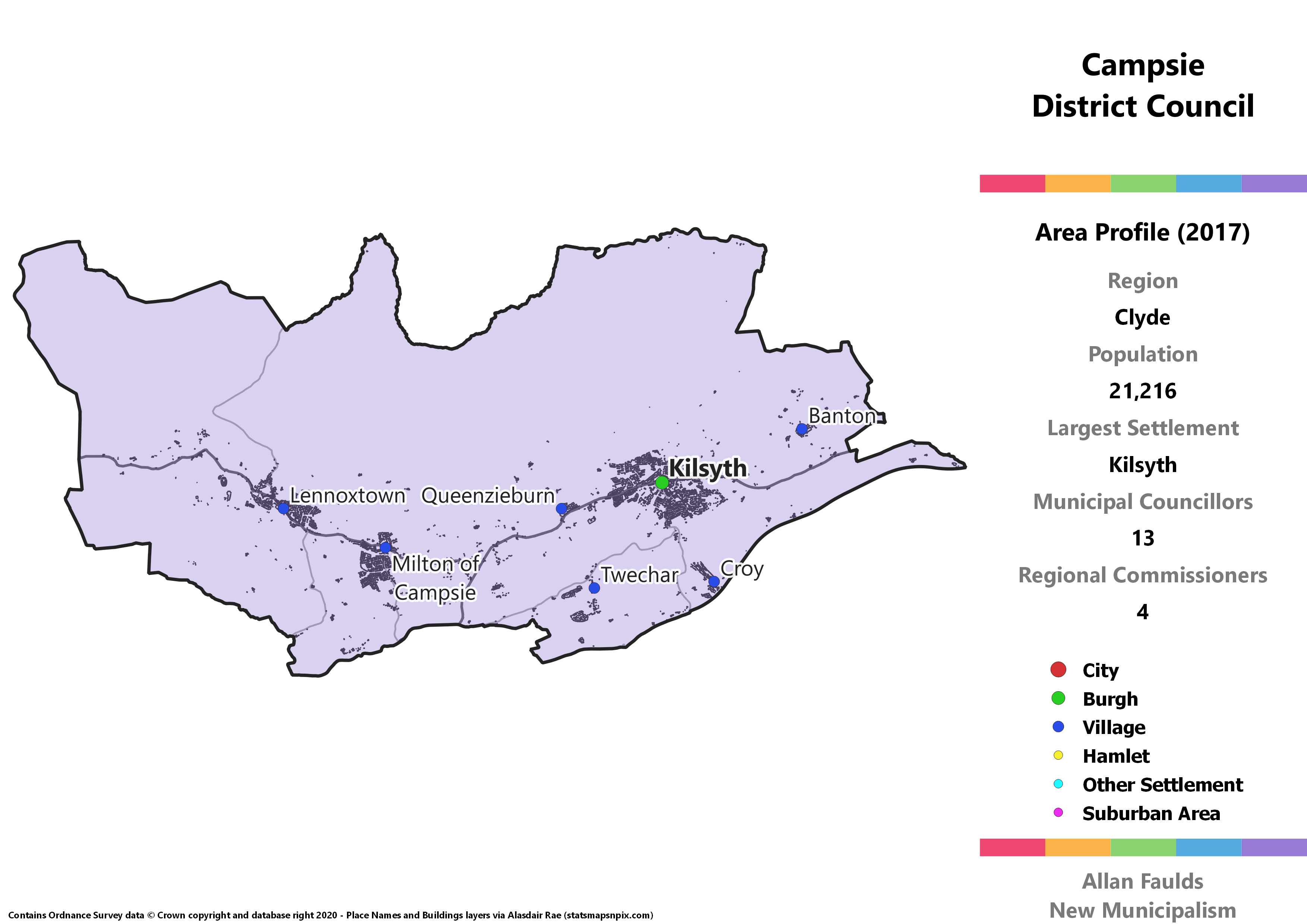
Area Profile (2017)
Population: 21,216
Largest Settlement: Kilsyth
Municipal Councillors: 13
Regional Commissioners: 4
Municipality Description
Campsie is a substantial break with the current Council arrangements, but somewhat sympathetic to historic boundaries. It merges the northern portion of the current East Dunbartonshire and North Lanarkshire councils. However, most of this area was historically part of Stirlingshire, so recombining them here isn’t without precedent. Twechar and Croy are historically Dunbartonshire, but nestled between two big burghs fit best in with these smaller towns and villages.
Looking at it on a normal map would show a major road running as an artery though Kilsyth, Milton of Campsie and Lennoxtown, so clearly these villages are well linked as it stands. It’s a neater fit in other senses too as the Campsie villages, especially Lennoxtown, aren’t quite as affluent as their southern and western neighbours in East Dunbartonshire. Kilsyth in particular might find it a bit awkward to be in their third different regional unit in half a century, but you can’t reform local government without a few strange bits.
Central Renfrewshire District
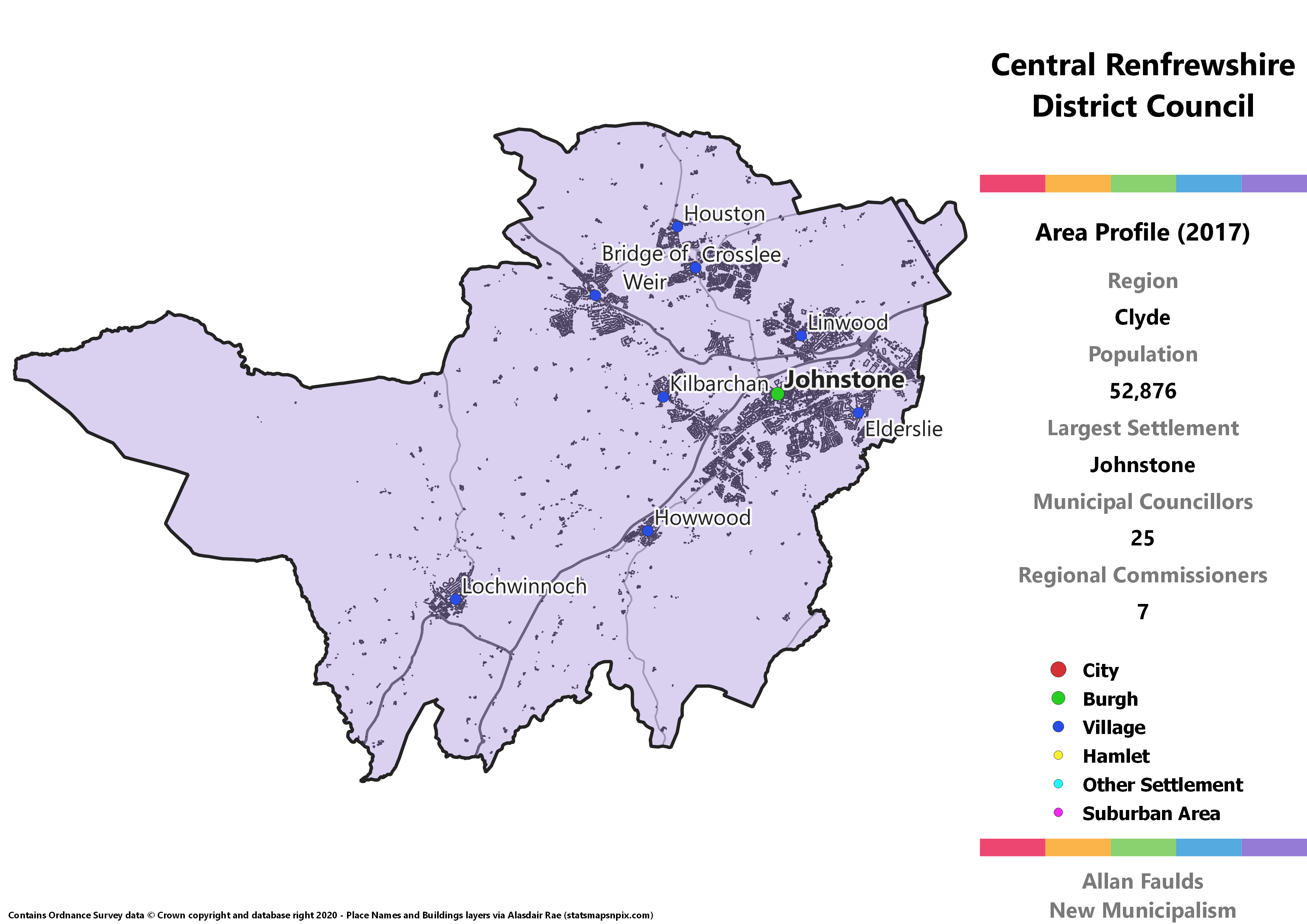
Area Profile (2017)
Population: 52.876
Largest Settlement: Johnstone
Municipal Councillors: 25
Regional Commissioners: 7
Municipality Description
Covering a rather large population for a district with so many separate towns, Central Renfrewshire takes in most of the inland portion of the current Renfrewshire council area. It’s effectively defined by two rivers. The southern leg follows the Black Cart water, starting at Lochwinnoch and passing through Howwood, Kilbarchan, Johnstone and Linwood. The northern leg follows the River Gryffe through or past Bridge of Weir, Crosslee and Houston.
Wanting to stick to the route of those rivers plus the need to put the rural area around Lochwinnoch and Howwod somewhere led me to just stick everything together here. Peeling Linwood off from the rest of the areas along the Black Cart would have allowed the northern portion to meet the 20,000 target and become its own district. That still strikes me as a reasonably sensible possibility, even though I didn’t go for it here.
Clydebank Burgh
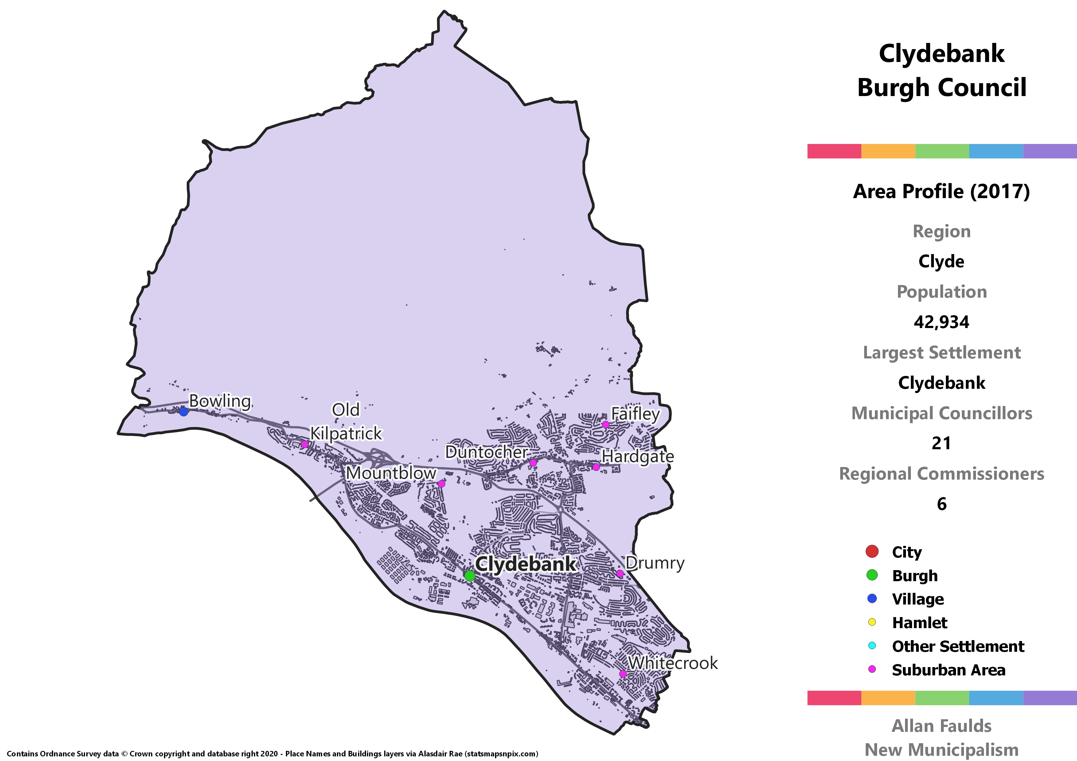
Area Profile (2017)
Population: 42,934
Largest Settlement: Clydebank
Municipal Councillors: 21
Regional Commissioners: 6
Municipality Description
Another almost identical recreation of a 1973 Act district, Clydebank is by far a big enough town to justify its own Burgh council. Compared to the pre-1973 Burgh, the town has definitely expanded to take in Hardgate and Duntocher, plus Mountblow and Old Kilpatrick in the west. The only real difference to the old district is that it includes the village of Bowling. Since the village is statistically considered part of the Greater Glasgow settlement, it made sense to tie it in with Clydebank as a a whole.
Dumbarton Burgh
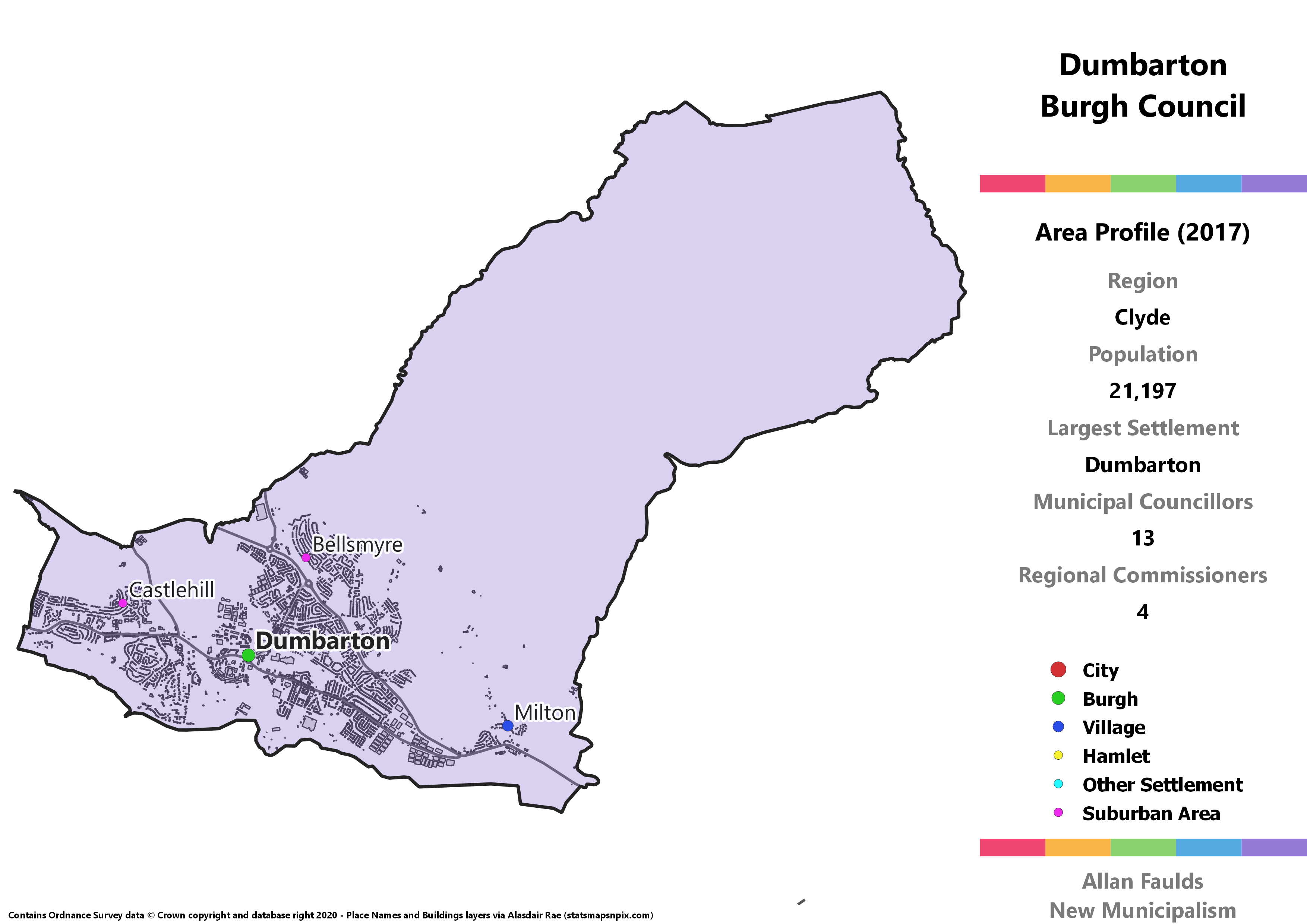
Area Profile (2017)
Population: 21,197
Largest Settlement: Dumbarton
Municipal Councillors: 13
Regional Commissioners: 4
Municipality Description
One of the many large towns in Scotland that used to be a Burgh in its own right, that status would have been maintained basically anywhere but the UK. It’s also one of many towns in Scotland to lend its name to a county only to be displaced in terms of size and economic importance, in this case by Clydebank.
The only real differences in extent between this version and the old style Burgh is the inclusion of the village of Milton. The big rural lobe to the north east doesn’t actually have anyone living in it, but in a system where every part of the country is within a municipality it has to go somewhere. The reality of areas like this – it’s mostly bits of the Kilpatrick Hills – is that it’d probably come under the purview of the Regional council as some form of protected area.
Yes, the town is DuMbarton and the county is DuNbartonshire. The N is closer to the original Gaelic name, but the M is what the town is now called and counties draw their names from towns, so you could argue the toss for which one to standardise to. That’s probably why it has never been standardised, as there’s more argument than agreement.
Note the political oddity in the chart below which is a West Dunbartonshire Community Party councillor. Ahead of the 2017 election, Dumbarton (then) Independent councillor George Black participated in the founding of that party. Although he wasn’t re-elected for Dumbarton ward, with full Burgh status he would have been. Whether a WDCP would have existed in that scenario is another matter.
Eastwood North and Eaglesham District
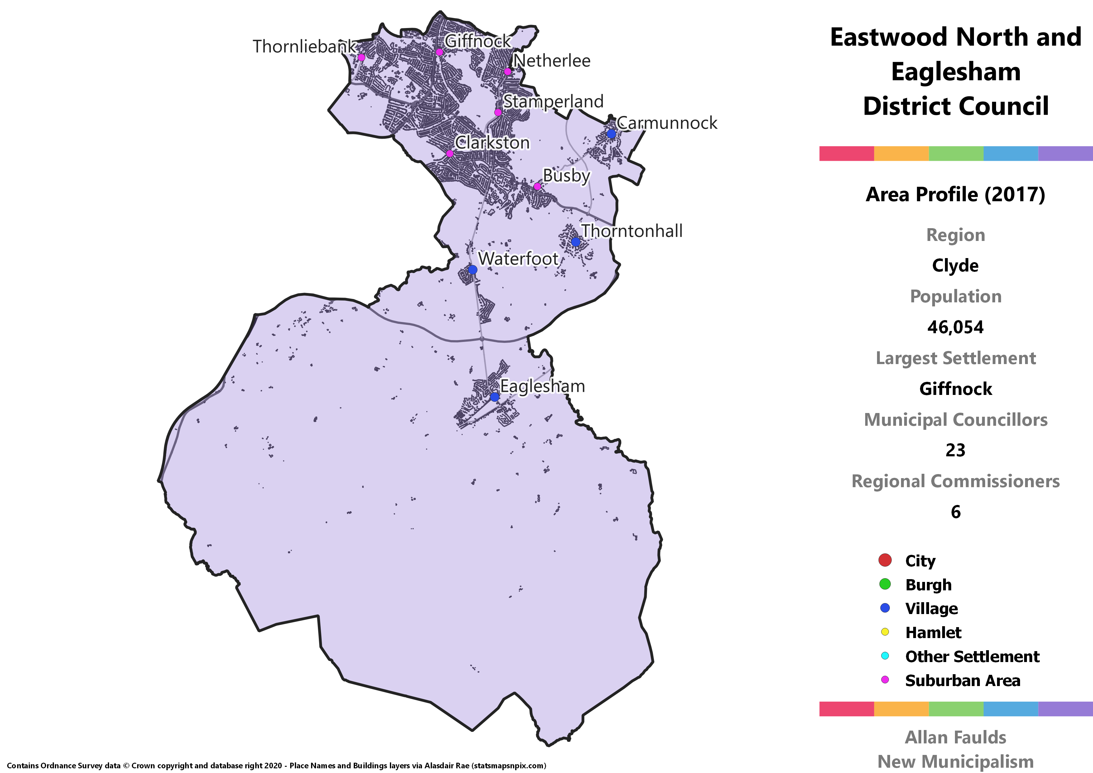
Area Profile (2017)
Population: 46,054
Largest Settlement: Giffnock
Municipal Councillors: 23
Regional Commissioners: 6
Municipality Description
That’s something about the Easts in the West of Scotland, as the current East Renfrewshire is (largely) similar to East Dunbartonshire in being home to many affluent Glasgow suburbs. Eastwood North and Eaglesham covers about two thirds of the 1973 Act’s Eastwood district, with most of the population in a tight cluster of those Glasgow suburbs, including Giffnock, Clarkston and Thornliebank.
As there’s not really anywhere else it’d fit, the district also incorporates the small village of Waterfoot, the larger village of Eaglesham, plus most of rural southern East Renfrewshire. More notably though, it has detached the villages of Carmunnock and Thorntonhall from Glasgow and South Lanarkshire, respectively. Both of these villages are relatively isolated from much larger urban areas in their current councils, and are reasonably affluent and so would fit the general Eastwood demographic better.
Carmunnock does however bring with it the only SIMD top 20% most deprived areas that’d be in either of the Eastwood municipalities. Whereas Barrhead and Neilston leans heavily towards the SNP and Labour, and Newton Mearns leans heavily towards the Conservatives, this district would be more evenly split.
Erskine District
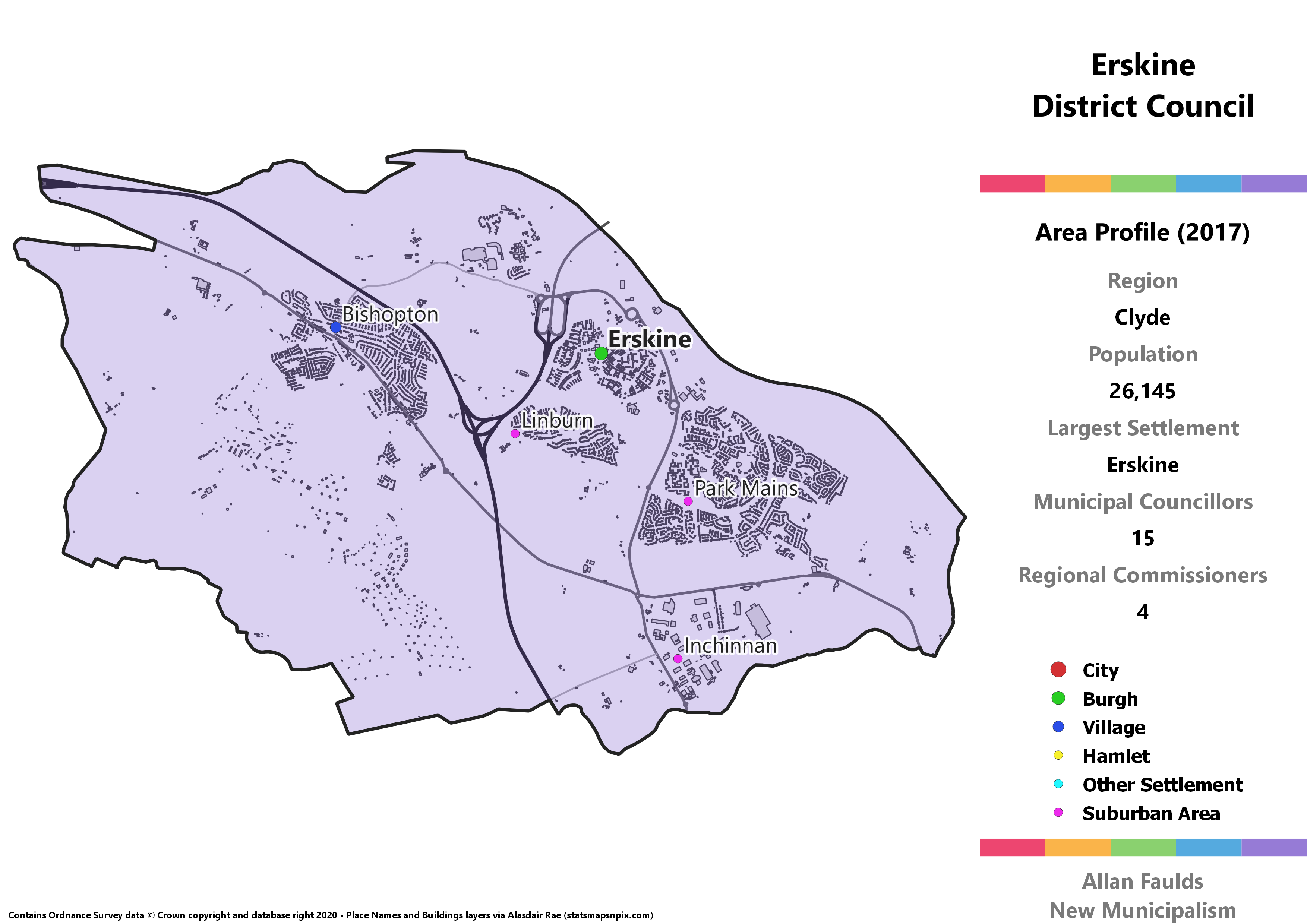
Area Profile (2017)
Population: 26,145
Largest Settlement: Erskine
Municipal Councillors: 15
Regional Commissioners: 4
Municipality Description
This district is centred on the town of Erskine, with the only other major and completely separate settlement being the village of Bishopton. By Renfrewshire standards, this is an area of low deprivation, especially in Bishopton which is one of the least deprived areas anywhere in Scotland. Beyond that, there’s nothing much to make this district stand out, or much in need of explanation.
Greenock District

Area Profile (2017)
Population: 62,157
Largest Settlement: Greenock
Municipal Councillors: 27
Regional Commissioners: 8
Municipality Description
This one is actually quite frustrating. The thing about the current Inverclyde council is that it’s mostly merged into a single urban agglomeration along the north coast, with outlying villages in the south west and south east. So although Greenock is big enough by far to stand alone, and Gourock has history as an independent Burgh too, it’s not terribly easy to disentangle them.
You could just about scrape a “Gourock and Firth Coast” district covering Gourock, Inverkip, Wemyss Bay and Skelmorlie here if you really tried, though it’d be nearly 1,000 folk short of the threshold. Doing so would also relatively neatly split the area into an affluent and a working class end. I’ve opted not to do so here, but it’s an option I guess.
Skelmorlie has been nicked from North Ayrshire on the basis that it’s effectively contiguous with Wemyss Bay now. You could tan the windows of Wemyss Bay station in from parts of Skelmorlie they are that close. I’m happy enough to break traditional county lines here as it’s such a wee bit.
There are also a pair of lesser-spotted South of the Clyde Lib Dems in the hypothetical 2017 election result here. Believe it or not, Inverclyde had a brief spell as a Lib Dem majority council in the last term before STV was brought in, and they clearly retain some lingering support here.
Helensburgh and West Lomond District
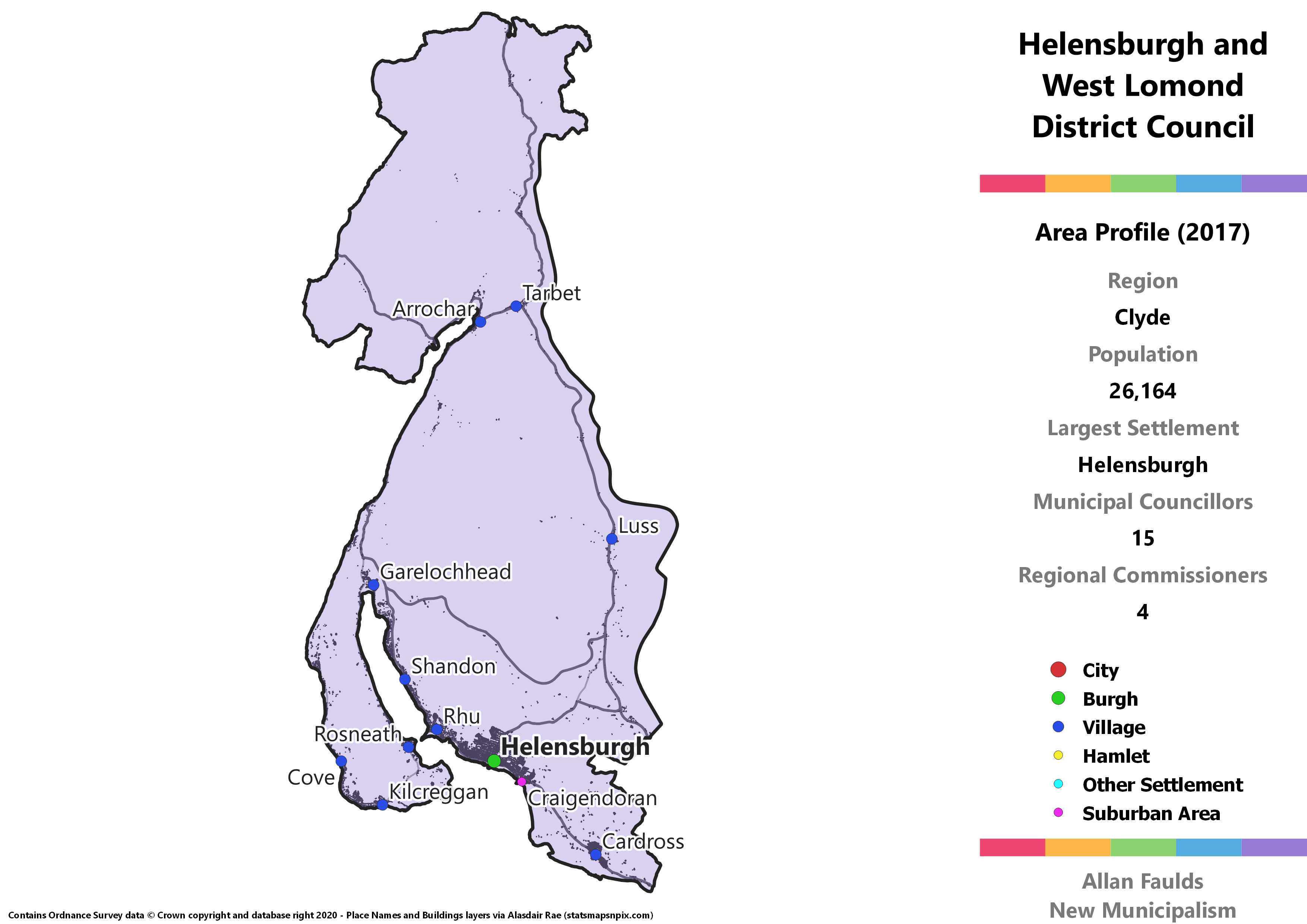
Area Profile (2017)
Population: 26,164
Largest Settlement: Helensburgh
Municipal Councillors: 15
Regional Commissioners: 4
Municipality Description
Although this area is currently in Argyll and Bute, that’s a relatively recent state of affairs. Historically the Helensburgh and West Lomond area has been the westernmost reach of Dunbartonshire, and was part of the Dumbarton district under the 1973 Act. It opted by local referendum to join A&B ahead of the 1994 Act, feeling they’d fit better there.
Despite that, this is an area that maintains substantial social integration with the neighbouring Dumbarton and Vale of Leven areas. Being from the Vale, it definitely felt to me growing up that whilst each of the three parts were distinct, they formed a wider whole. Especially given the rest of Argyll is tied into the Highlands under my scheme, it makes sense to bring Helensburgh back into the historic Dunbartonshire fold via the Clyde region.
That does mean this is the most rural of the Clyde districts, though most of the population is in Helensburgh which is very much within the Glasgow commuter belt. As Helensburgh is the most affluent town in western Dunbartonshire, it’s perhaps no surprise that the Conservatives would be easily the strongest party here.
Kirkintilloch and Lenzie Burgh
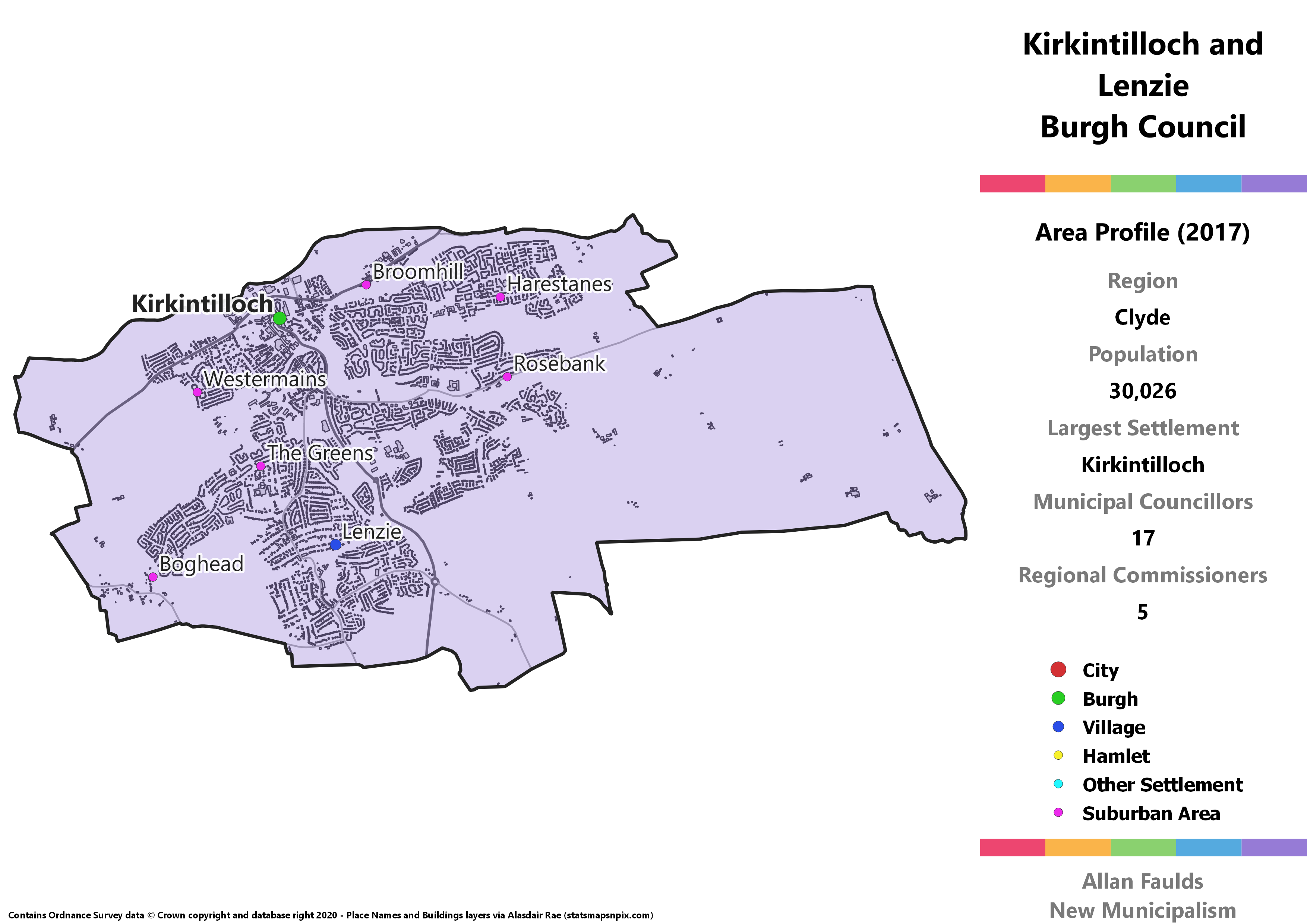
Area Profile (2017)
Population: 30,026
Largest Settlement: Kirkintilloch
Municipal Councillors: 17
Regional Commissioners: 5
Municipality Description
Contrary to the image of the rest of East Dunbartonshire as leafy, affluent Glasgow suburbs, Kirkintilloch and Lenzie would be a much more well-mixed Burgh. The Kirkintilloch end is home to the majority of the current East Dunbartonshire’s most deprived areas, whilst Lenzie fits the posh and leafy mold.
Kirkintilloch does have previous experience with its own council, though both it and Lenzie have expanded since then. The combined population would once again qualify them for a burgh council after decades as part of larger districts per my rules.
Newton Mearns Burgh
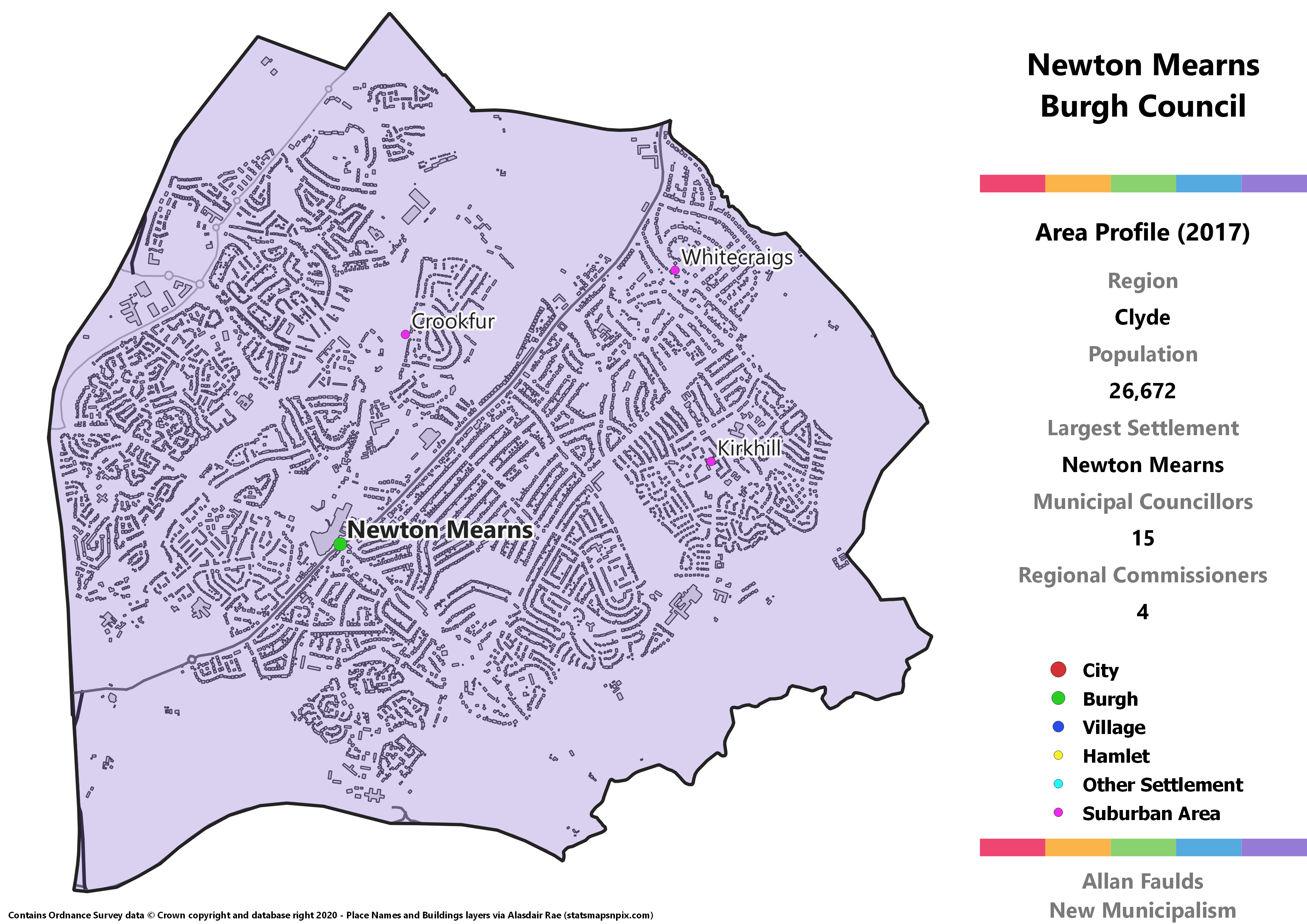
Area Profile (2017)
Population: 26,672
Largest Settlement: Newton Mearns
Municipal Councillors: 15
Regional Commissioners: 4
Municipality Description
As the name implies, Newton Mearns is a relatively new town, springing up during the mid 20th century. That means that despite its current size, it never before had its own Burgh council. In the terms of this project (and most of Europe) however, it more than qualifies for one.
Newton Mearns is the largest of the East Renfrewshire towns and villages that has become attached to Glasgow. It’s a mostly very affluent town, though an area in the south west near the shopping centre falls in the most deprived half of the SIMD. It’s also one of the most Conservative leaning places in Scotland, with the party winning two-thirds of the seats according to an extrapolation of 2017 results.
Paisley Burgh
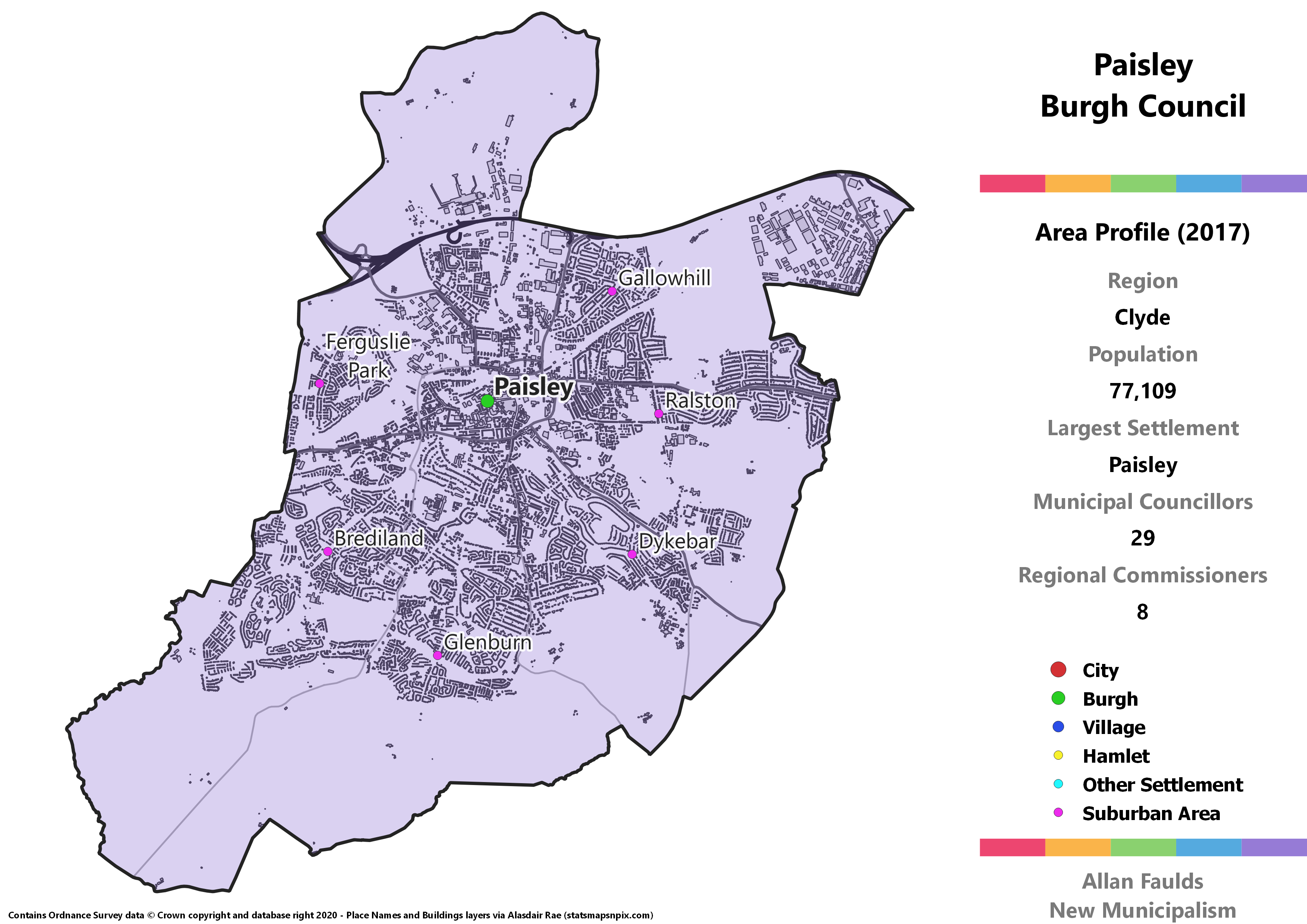
Area Profile (2017)
Population: 77,109
Largest Settlement: Paisley
Municipal Councillors: 29
Regional Commissioners: 8
Municipality Description
Paisley is Scotland’s largest town by population, larger than the three smaller cities. Were it not so close to and so well integrated with Glasgow, it’d likely have city status. Regardless of whether it’s a town or a city, the fact it doesn’t currently have its own council is one of the great absurdities of Scotland’s current system of not very local government. Restoring its historic Burgh Council is one of the easiest changes to justify in this project.
Thanks in part to having such a large number of seats to fill, Paisley comes out as a highly diverse council if we extrapolate from 2017 results. Each of the 5 major parties would be represented here, as well as a particularly popular independent.
Port Glasgow District
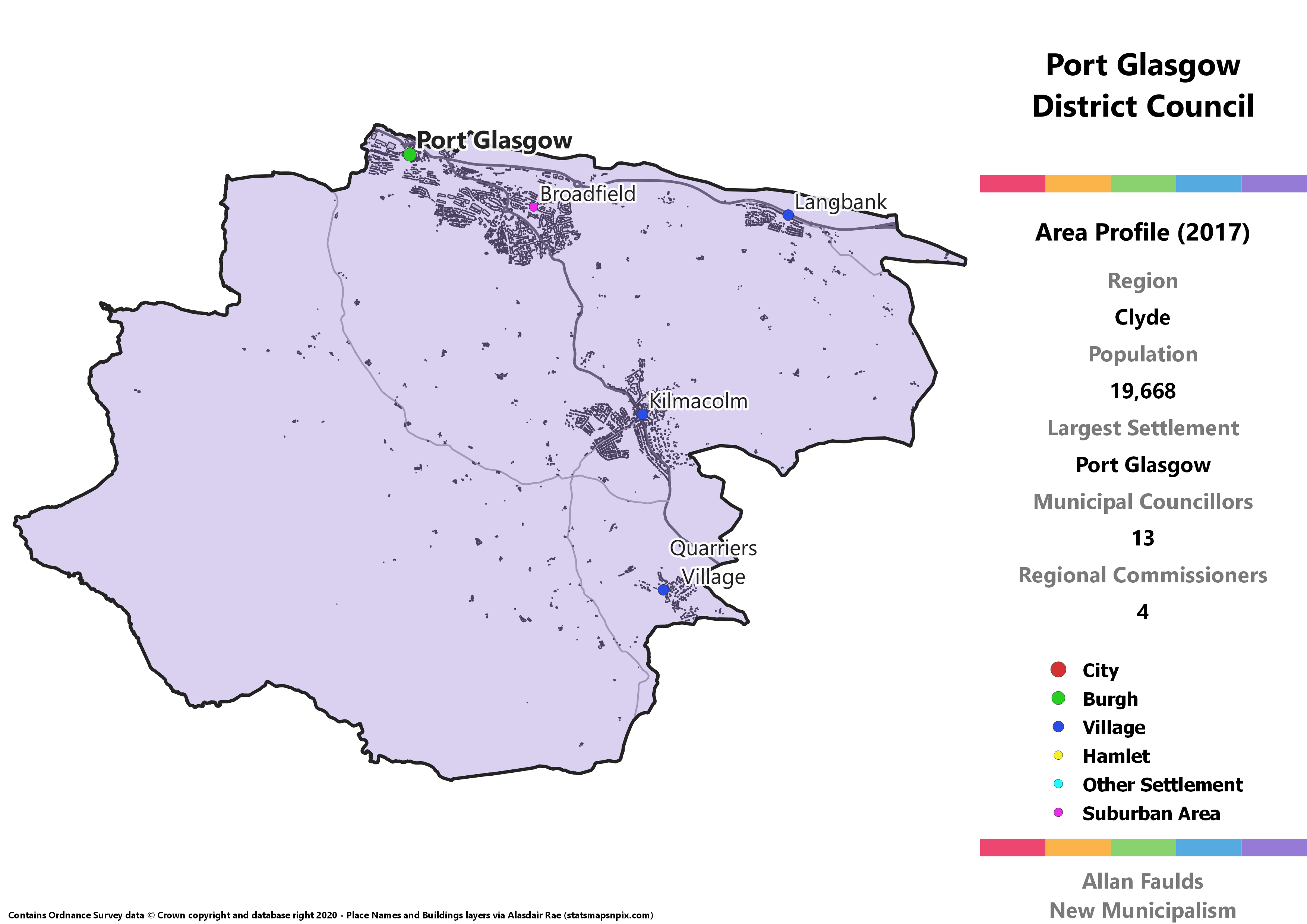
Area Profile (2017)
Population: 19,668
Largest Settlement: Port Glasgow
Municipal Councillors: 13
Regional Commissioners: 4
Municipality Description
Port Glasgow is effectively the only bit I felt reasonably able to shave off of the current Inverclyde, but even with the addition of Langbank from Renfrewshire it still comes in marginally below the 20,000 residents threshold. The difference between Port Glasgow and Gourock then is effectively that since this rounds to 20,000 and that rounded to 19,000, I let this one through.
It is slightly awkward however in that it combines two very different areas. Port Glasgow itself remains one of the most deprived areas of Scotland, with almost the entire town coming within the most deprived 20% according to SIMD 2016. By contrast, the outlying villages of Langbank, Quarrier’s Village and especially Kilmacolm are amongst the least deprived. When there are larger populations involved I often try to separate such clearly divided areas so the proposed councils would be more responsive to particular needs, but that wasn’t really possible here.
That stark division is likely how Port Glasgow ends up the only part of Renfrewshire outside of Eastwood to have the Conservatives as the largest party when extrapolating from 2017 results, whilst still handing the majority of seats to the SNP and Labour.
Renfrew Burgh
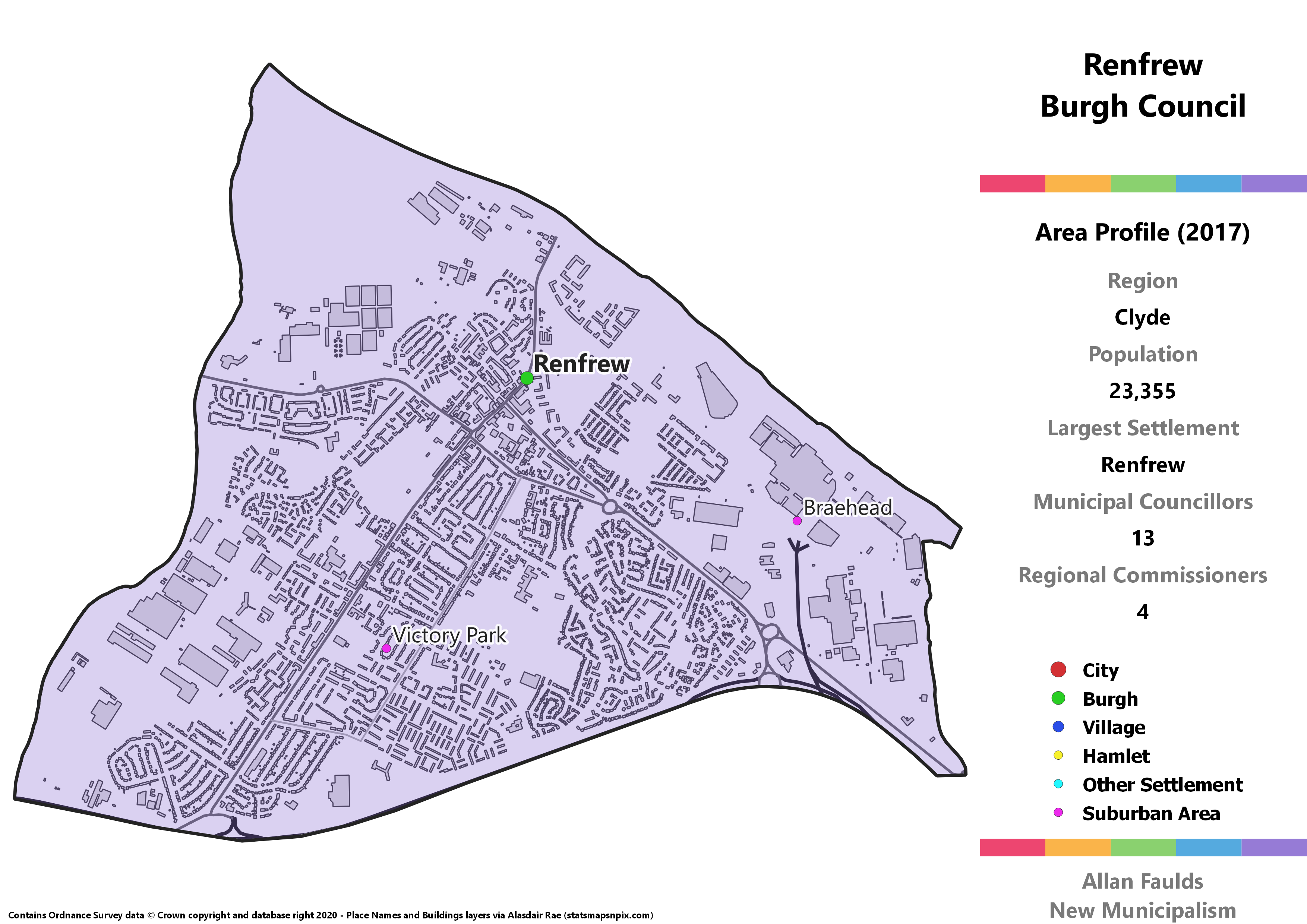
Area Profile (2017)
Population: 23,335
Largest Settlement: Renfrew
Municipal Councillors: 13
Regional Commissioners: 4
Municipality Description
Despite lending its name to the county, Renfrew itself has long since been eclipsed by neighbouring Paisley. Nonetheless, it’s still a sizeable town, and one that comfortably meets the criteria for its own Burgh council according to my rules.
There isn’t very much to say about Renfrew beyond that, but if you’re itching for a few more Renfrew facts, I can confirm it has one of the most gorgeous town halls anywhere in the country. It’s also the largest town in Scotland not to be on the railway at all, never mind not served by a station.
Vale of Leven District
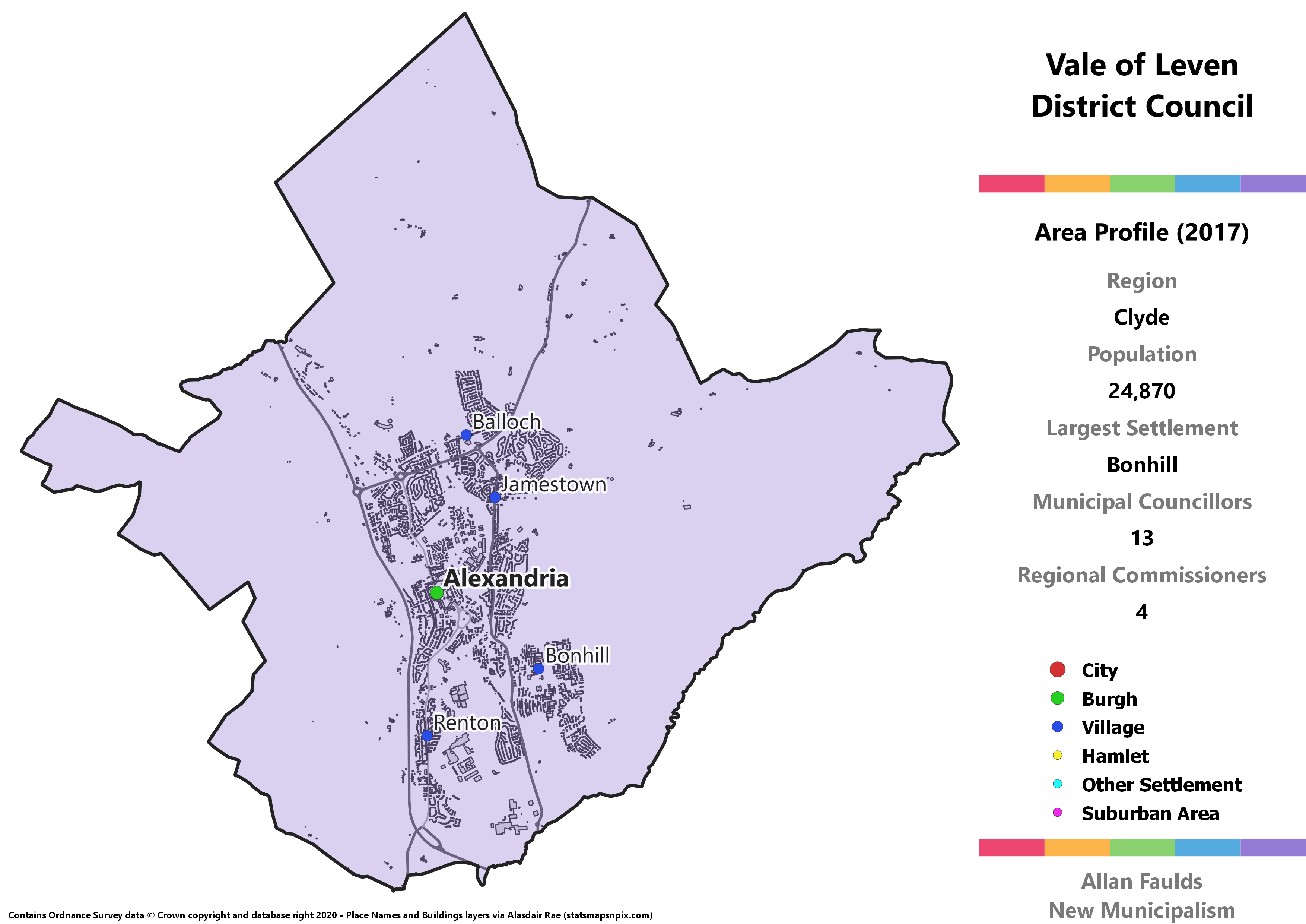
Area Profile (2017)
Population: 24,870
Largest Settlement: Bonhill
Municipal Councillors: 13
Regional Commissioners: 4
Municipality Description
The Vale of Leven is without a doubt the finest municipality in the entire Clyde region, and that statement has absolutely nothing to do with the fact it’s where I was born and grew up. Specifically I’m from Bonhill, so it tickles me that it’s the biggest settlement in the area, even though Alexandria is very much the centre of the Vale and Balloch is the tourist hub.
The Vale of Leven basically consists of five villages that have grown into one another over the decades – Alexandria, Balloch, Bonhill, Jamestown and Renton. I definitely feel like there’s quite a distinct sense of local identity that binds them together as well. Given the sizeable population, it’s therefore exactly the kind of place that I think would be deserving of its own municipality if Scotland followed the more mainstream European model of local government.
Folk familiar with the area or the current West Dunbartonshire in general might notice that the village of Gartocharn is nowhere to be seen. It feels a bit separate, and is quite well linked in with areas like Drymen, Balfron and Balmaha which are currently and historically in Stirling. I therefore opted to break county lines here and transfer Gartocharn out of the Vale and thus the Clyde region overall.
Another of the Vale’s distinguishing features is a strong association with the Left for many years. It’s claimed – though I haven’t been able to find the evidence – that the old pre-1973 Act district was the only place in the UK where Communists were ever the largest group on the council. That heritage is represented today by councillor Jim Bollan, who has held a seat in the area in some form since 1989.
He’s been Labour, a Communist, an Independent, was the Scottish Socialist Party’s only councillor from 2007 to 2017, and finally helped form the West Dunbartonshire Community Party ahead of 2017, under which banner he was duly elected. He’s a very popular and well-respected figure locally, especially in Renton which has long been his base of support, and his vote is what delivers two councillors for the WDCP when we extrapolate the 2017 results.